Current Road Condition and Route Map
| Visited | Stop Name | Type |
|---|---|---|
| Newberry Opera House | Point of Interest | |
| Enoree River Rest Area | Rest Area | |
| Spartanburg Gas Stations | Gas Station | |
| Downtown Landrum | Point of Interest | |
| Pearson's Falls and Glen | Point of Interest | |
| Hendersonville Welcome Center | Rest Area | |
| The Biltmore Estate | Point of Interest | |
| River Arts District | Point of Interest | |
| Wheels Through Time Museum | Point of Interest | |
| Soco Falls | Point of Interest |

Distance and estimated driving time
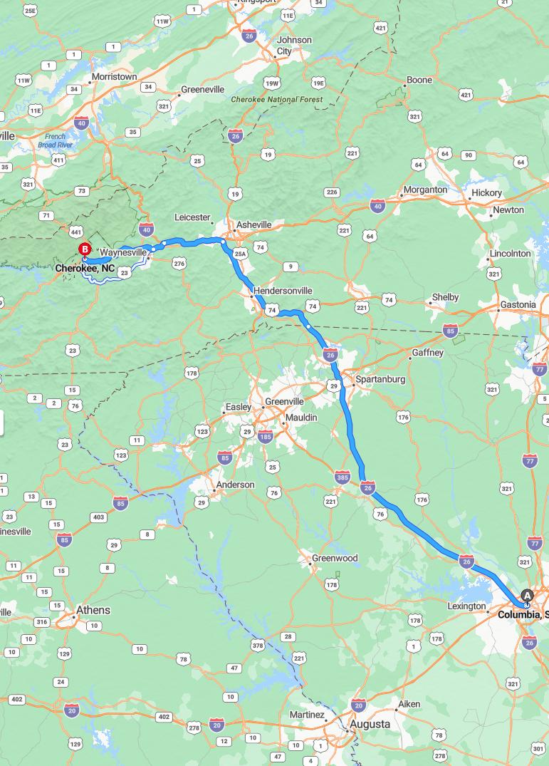
The drive from Columbia to Cherokee covers approximately 198 miles and takes around 3 hours and 7 minutes, depending on traffic conditions. Travelers will primarily follow Interstate 26 West and US-19 South, providing a scenic route through the southeastern United States. This journey offers a convenient route for those exploring the region or heading towards the Appalachian Mountains. Planning for potential delays can ensure a smooth trip, allowing travelers to enjoy their visit without stress.
Driving route
Embarking on a scenic drive from Columbia, South Carolina to Cherokee offers a rich journey through charming towns and picturesque landscapes. Starting in Columbia, travelers pass through Lexington, known for its vibrant community and local eateries. Continuing northwest, Greenwood provides a glimpse into small-town charm before reaching Spartanburg, a hub of history and culture. The route then leads through Hendersonville and Asheville, renowned for their vibrant arts scenes and beautiful mountain vistas. Finally, the drive concludes in Cherokee, offering a gateway to the scenic beauty and Native American heritage of the Appalachian Mountains.
Road conditions and potential delays
Driving from Columbia to Cherokee, travelers should prepare for varying road conditions along the route. While most highways are generally in good condition, occasional construction or maintenance work may cause minor delays, especially around Spartanburg and Asheville. Weather can also impact driving, with rain or fog potentially reducing visibility and traction in the Hendersonville and Asheville areas. It's advisable to check local traffic updates before departure to stay informed about any ongoing roadwork or delays that could affect travel time.
Scenic attractions along the route
As you drive from Columbia to Cherokee, you'll encounter a variety of scenic attractions that showcase the region's natural beauty. Starting in Columbia, the picturesque landscapes of Lexington and Greenwood offer charming lakeside views and lush greenery. Continuing through Spartanburg and Hendersonville, travelers can enjoy scenic mountain vistas and vibrant fall foliage, especially in the Blue Ridge Mountains. As you approach Asheville, the breathtaking Blue Ridge Parkway provides panoramic views, culminating in the scenic allure of Waynesville before reaching the culturally rich town of Cherokee.
Travel safety tips
When driving from Columbia to Cherokee, it is essential to prioritize safety by ensuring your vehicle is well-maintained before the trip. Stay alert and avoid distractions, especially in scenic areas like Asheville and Waynesville, where breathtaking views can divert your attention. Follow posted speed limits and be cautious on mountain roads, which may have sharp turns and changing weather conditions. Finally, keep an emergency kit, including water, first aid supplies, and a charged phone, to be prepared for any unforeseen circumstances along the route.
Best places to stop for fuel and refreshments
When driving from Columbia to Cherokee, several convenient stops for fuel and refreshments can enhance your trip. Lexington and Greenwood are excellent first stops, offering numerous gas stations and local cafes for quick breaks. Spartanburg and Hendersonville provide larger facilities with a variety of dining options and fuel stations, making them ideal for a more substantial pause. Asheville and Waynesville also boast numerous service stations and charming eateries, allowing travelers to refresh before reaching their final destination in Cherokee.
Local traffic regulations and laws
When driving from Columbia to Cherokee, it is essential to adhere to local traffic regulations and laws to ensure a safe journey through South Carolina and North Carolina. Speed limits vary by area, with stricter enforcement in urban and school zones, so drivers should remain attentive to posted signs. Seatbelt use is mandatory for all occupants, and texting while driving is prohibited across both states. Additionally, be mindful of local laws regarding alcohol consumption and vehicle requirements, such as insurance and registration, to avoid penalties and enjoy a trouble-free trip.
Weather forecast for the driving day
The weather forecast for the driving day from Columbia to Cherokee indicates mostly clear skies with mild temperatures throughout the route. Travelers can expect pleasant conditions in Columbia, Lexington, and Greenwood, with no significant weather disruptions. As the journey progresses through Spartanburg, Hendersonville, Asheville, and Waynesville, light clouds may appear, but heavy rain or storms are not forecasted. Overall, drivers should enjoy smooth traveling conditions, although it's advisable to stay updated on local weather alerts for any sudden changes.
Accommodation options near Cherokee
When traveling to Cherokee, visitors have a variety of accommodation options nearby to suit different preferences and budgets. Options include cozy mountain lodges and cabins that provide a rustic, authentic experience, as well as affordable motels and hotels offering modern amenities for comfort. For those seeking a more luxurious stay, several upscale resorts and boutique inns are available, often featuring scenic views and spa services. Additionally, vacation rentals such as cabins and cottages offer flexibility and a homely atmosphere, making it easy to relax and enjoy the beautiful surroundings of the Great Smoky Mountains.
Recommended travel apps and navigation tools
When driving from Columbia to Cherokee, utilizing reliable navigation apps like Google Maps or Waze can significantly enhance your journey by providing real-time traffic updates and the fastest routes through cities like Lexington, Greenwood, Spartanburg, Hendersonville, Asheville, and Waynesville. These apps help you avoid delays and offer alternate routes in case of unexpected road closures or congestion. Additionally, offline maps are useful in areas with limited service, ensuring continuous navigation near rural or mountainous regions. For a more comprehensive travel experience, consider integrating apps such as TripAdvisor for points of interest along the way, making your trip both smooth and enjoyable.
Leave a comment