Current Road Condition and Route Map
| Visited | Stop Name | Category | Description |
|---|---|---|---|
| San Francisco de Asís Mission Church | Point of Interest | Iconic historic adobe church in Ranchos de Taos. | |
| Sipapu Ski & Summer Resort | Rest Area / Food | Year-round resort offering dining and restroom facilities. | |
| Sugar Nymphs Bistro | Restaurant | Local favorite in Peñasco for fresh food and baked goods. | |
| Carson National Forest Overlooks | Point of Interest | Scenic pull-offs with panoramic views of the Sangre de Cristo Mountains. | |
| Allsup's Convenience Store (Mora) | Gas Station | Essential stop for fuel and snacks in the Mora Valley. | |
| St. Gertrude's Church | Point of Interest | Beautiful historic stone church located in the heart of Mora. | |
| Salman Raspberry Ranch | Point of Interest | Seasonal farm famous for fresh raspberries and local preserves. | |
| Storrie Lake State Park | Rest Area | Ideal spot for a lakeside picnic just outside Las Vegas. | |
| Old Town Plaza | Point of Interest | The historic heart of Las Vegas with unique architecture. | |
| Montezuma Hot Springs | Point of Interest | Natural hot springs located just a few miles north of Las Vegas. |

Distance and estimated driving time
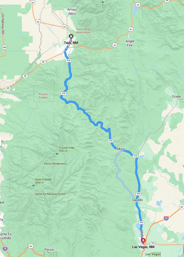
The drive from Taos to Las Vegas covers approximately 77 miles via NM-518. The trip typically takes around 1 hour and 39 minutes, depending on traffic conditions. This scenic route offers travelers a convenient and efficient way to reach Las Vegas from Taos. Planning ahead ensures a smooth journey with ample time to enjoy the picturesque New Mexico landscape along the way.
Driving route
Embarking on a scenic drive from Taos, New Mexico, to Las Vegas, NM, offers travelers a captivating journey through diverse landscapes. The route begins in Taos, renowned for its rich cultural heritage and stunning art scene, before heading south through Arroyo Seco, a charming mountain town. Continuing south, you'll pass through Angel Fire, famous for its ski resort and outdoor activities, then visit Ocate, a peaceful rural community nestled in the Sangre de Cristo Mountains. As you traverse through Mora and Sapello, you'll experience scenic vistas and quiet rural settings that highlight the region's natural beauty. Finally, the journey culminates in Las Vegas, NM, a historic city known for its preserved 19th-century architecture and vibrant cultural atmosphere.
Road conditions and weather forecast
The drive from Taos to Las Vegas, NM, passes through scenic mountain and rural areas, with road conditions generally favorable but sometimes affected by seasonal weather changes. Travelers should be prepared for potential snow or ice, especially near Angel Fire and Mora, during colder months, which can impact driving safety. Weather forecasts indicate clear skies and mild temperatures over the next few days, making for a smooth journey, but it is advisable to check real-time updates before departure. Being alert to changing conditions ensures a safe and enjoyable trip through this picturesque route.
Best rest stops and amenities along the route
Along the drive from Taos to Las Vegas, NM, travelers can enjoy several convenient rest stops with beneficial amenities. In Arroyo Seco, visitors can find small cafes and rest areas, perfect for a quick break. Angel Fire offers scenic viewpoints and nearby recreational facilities, ideal for stretching legs and enjoying the outdoors. As you approach Mora and Sapello, roadside spots with picnic areas and basic amenities provide comfort before continuing the journey to Las Vegas. These stops ensure a refreshing and comfortable trip across the scenic New Mexico landscape.
Scenic attractions and viewpoints en route
As you drive from Taos to Las Vegas, NM, you'll encounter stunning scenic attractions and captivating viewpoints. Arroyo Seco offers picturesque canyon vistas and lush greenery, perfect for photography enthusiasts. Angel Fire presents breathtaking mountain landscapes and scenic overlooks that showcase the rugged beauty of the Sangre de Cristo Range. Continuing through Ocate, Mora, and Sapello, travelers can enjoy peaceful rolling hills, vibrant fall foliage, and expansive open skies, culminating in the charming atmosphere of Las Vegas, NM.
Safety tips for long-distance travel
Embarking on a long-distance road trip from Taos to Las Vegas, NM requires careful planning to ensure safety. It is essential to get adequate rest before starting your journey and take regular breaks to stay alert while driving. Make sure your vehicle is well-maintained, with tire pressure and fluid levels checked, and carry a safety kit in case of emergencies. Staying focused on the road, obeying speed limits, and avoiding distractions like mobile devices will help ensure a safe and enjoyable trip through scenic towns like Arroyo Seco, Angel Fire, and Mora.
Fuel stations and pricing overview
The drive from Taos to Las Vegas, NM, passes through several towns offering fuel station options, with prices typically ranging from $3.00 to $3.50 per gallon for regular unleaded. In Arroyo Seco and Angel Fire, fuel stations are available but may have slightly higher prices due to their remote locations, averaging around $3.45 per gallon. As you approach Mora, Sapello, and Las Vegas, NM, fuel prices tend to stabilize, with some stations offering competitive rates, especially in Las Vegas itself, where prices may dip closer to $3.25 per gallon. It is advisable to refuel at major stations earlier in the route to ensure sufficient coverage, particularly considering potential fluctuations in fuel prices and limited options in the more rural segments.
Local regulations and driving laws in Nevada and New Mexico
When driving between Taos, New Mexico, and Las Vegas, Nevada, it's important to be aware of the distinct traffic laws in each state. New Mexico requires all drivers to carry proof of insurance, adhere to posted speed limits, and observe seat belt regulations for all passengers. Nevada mandates the use of headlights during adverse weather conditions and enforces strict DUI laws, with heavy penalties for violations. Both states participate in the Interstate Compact, ensuring some consistency, but travelers should familiarize themselves with specific local regulations such as cell phone use restrictions and roadside safety laws to ensure a safe journey.
Recommended accommodations and lodging options
While driving from Taos to Las Vegas, NM, travelers have several cozy accommodations along the route. In Taos, options range from charming bed and breakfasts like the Historic Taos Inn to luxury resorts such as the Hotel Luna Mystica, offering a variety of experiences. Near Angel Fire, visitors can choose from rustic cabins or mountain lodges that provide scenic views and outdoor activities. In Las Vegas, NM, travelers can find historic inns and modern hotels downtown, ensuring comfortable stays after a day exploring the picturesque region.
Traffic updates and potential delays
Traveling from Taos to Las Vegas, NM, drivers should anticipate potential delays due to seasonal weather conditions and road construction along the route, especially around Angel Fire and Arroyo Seco. Traffic is generally light, but some areas may experience localized congestion during peak hours. Always check the latest updates before departure, as snow or icy patches could impact driving conditions in the higher elevations. Planning for extra travel time will help ensure a safe and stress-free trip through this scenic mountain corridor.

Leave a comment