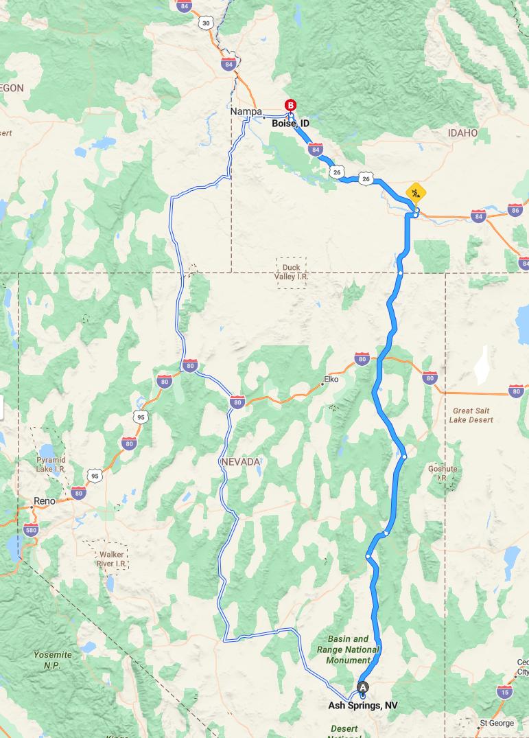
Current Road Condition and Route Map
| Select | Stop Name | Category | Description |
|---|---|---|---|
| Pahranagat National Wildlife Refuge | Point of Interest | Scenic wetlands and lakes in the high desert. | |
| Ely, Nevada | Gas Station / Food | Major mountain town with multiple fueling and dining options. | |
| Schellbourne Rest Area | Rest Area | Quiet stop along US-93 with restroom facilities. | |
| Lages Junction | Gas Station | Remote fueling point at the junction of US-93 and US-93 Alt. | |
| Wells, Nevada | Gas Station / Food | Strategic stop at the intersection with I-80. | |
| Jackpot, Nevada | Point of Interest / Gas | Casino town on the Idaho border with full amenities. | |
| Shoshone Falls Park | Point of Interest | The "Niagara of the West" located in Twin Falls. | |
| Perrine Memorial Bridge | Point of Interest | Stunning views of the Snake River Canyon. | |
| Malad Gorge State Park | Rest Area / POI | Dramatic canyon views right off I-84. | |
| Glenns Ferry | Gas Station / POI | Home to Three Island Crossing State Park and Oregon Trail history. |

Distance and estimated driving time
The journey from Ash Springs to Boise covers approximately 522 miles and is estimated to take around 7 hours and 58 minutes. The primary route involves traveling north on US-93, followed by west on I-84. This scenic drive offers a mix of desert landscapes and mountainous views, making it an engaging trip for travelers. Ensure to plan for rest stops and fuel stations along the way to maintain a comfortable and safe journey.
Driving route
Embarking on a drive from Ash Springs to Boise, travelers will journey through a diverse and scenic route. Starting in Ash Springs, the route first leads to Las Vegas, known for its vibrant entertainment and bustling atmosphere. Continuing northward, the trip passes through Goff and Ely, offering unique desert landscapes and regional charm. The final leg takes you into Boise, Idaho's vibrant capital, renowned for its parks, outdoor activities, and cultural scene. Overall, this drive combines striking desert scenery with lively urban destinations, making it an engaging journey.
Road conditions and weather forecast
The route from Ash Springs to Boise takes drivers through a diverse landscape, with road conditions generally favorable, though certain segments near Ely can experience winter weather and occasional snow. Travelers should be prepared for variable weather, especially as elevations change along the route, with the possibility of snow or icy patches in higher elevations. It's advisable to check current road conditions and weather forecasts before departure, as conditions can change rapidly, particularly in winter months. Overall, the journey offers scenic views and manageable driving conditions when proper precautions are taken.
Fuel stations and rest stops
Travelers driving from Ash Springs to Boise can find fuel stations and rest stops along the route, ensuring a comfortable journey. Starting in Ash Springs, there are initial options for refueling before heading south toward Las Vegas, where numerous gas stations and amenities are available. As you pass through Goff and Ely, additional rest stops and fuel stations provide convenient locations to recharge both your vehicle and yourself. Approaching Boise, you'll find well-equipped service stations and designated rest areas to prepare for the final leg of your trip, making the long drive safe and enjoyable.
Popular attractions along the route
Traveling from Ash Springs to Boise offers a variety of intriguing attractions along the way. In Las Vegas, visitors can explore world-famous casinos, vibrant entertainment shows, and iconic landmarks such as the Bellagio Fountains and the Las Vegas Strip. Continuing through Goff and Ely, travelers can enjoy outdoor adventures at Great Basin National Park, known for its stunning mountain scenery and diverse wildlife. Finally, once reaching Boise, attractions like the Boise River Greenbelt, the Old Idaho Penitentiary, and vibrant downtown scene provide enjoyable experiences for visitors and locals alike.
Safety tips for long-distance driving
When planning a long-distance drive from Ash Springs to Boise, it's essential to prioritize safety to ensure a smooth journey. Always check your vehicle's condition beforehand, including tire pressure, fluid levels, and brakes, to prevent breakdowns. Take regular breaks to rest, stretch, and stay alert, especially when passing through areas like Las Vegas, Ely, and Goff, where traffic patterns may vary. Additionally, keep emergency supplies such as water, snacks, a first aid kit, and a charged phone to handle unexpected situations confidently.
Traffic updates and potential delays
Travelers heading from Ash Springs to Boise should stay informed about current traffic conditions for a smooth journey. While most of the route through Ash Springs, Las Vegas, Goff, and Ely generally experiences moderate traffic, seasonal factors and peak hours can lead to delays, especially near urban centers. It's advisable to check real-time traffic updates before departure to anticipate any potential slowdowns or closures. Planning for occasional brief stops and maintaining flexibility can help ensure a safe and efficient trip to Boise.
Emergency services and roadside assistance
When traveling from Ash Springs to Boise, travelers can access emergency services and roadside assistance at various points along the route, including major cities like Las Vegas and Ely. Numerous roadside assistance providers offer services such as towing, tire changes, and fuel delivery to ensure safety during unexpected incidents. It is advisable to have a reliable contact for emergency services and a mobile app with local providers before embarking on the journey. Being prepared with emergency supplies and awareness of nearby service stations can help mitigate potential disruptions along this scenic route.
Local dining and accommodation options
Along the route from Ash Springs to Boise, travelers can enjoy a variety of local dining options, including cozy cafes and family-owned restaurants offering regional specialties. In Ash Springs and Las Vegas, numerous hotels and inns provide comfortable accommodations, with Las Vegas featuring a wide range of luxury resorts and budget-friendly options. As you pass through Goff and Ely, small motels and historic lodges offer charming and convenient places to stay. Upon reaching Boise, visitors can explore a vibrant culinary scene with farm-to-table restaurants and boutique hotels that cater to diverse tastes and preferences.
Navigation tools and route planning tips
When planning a road trip from Ash Springs to Boise, utilizing modern navigation tools like GPS devices and smartphone map applications can significantly enhance your journey by providing real-time traffic updates, alternative routes, and estimated arrival times. It's advisable to input your entire route beforehand, including key stops such as Las Vegas, Goff, and Ely, to ensure efficient pacing and avoid unexpected detours. Carrying physical maps as a backup is also wise, especially in areas with limited cell service. Additionally, checking for weather conditions and road closures before departure can help you make informed decisions and maintain a smooth, stress-free trip.

Leave a comment