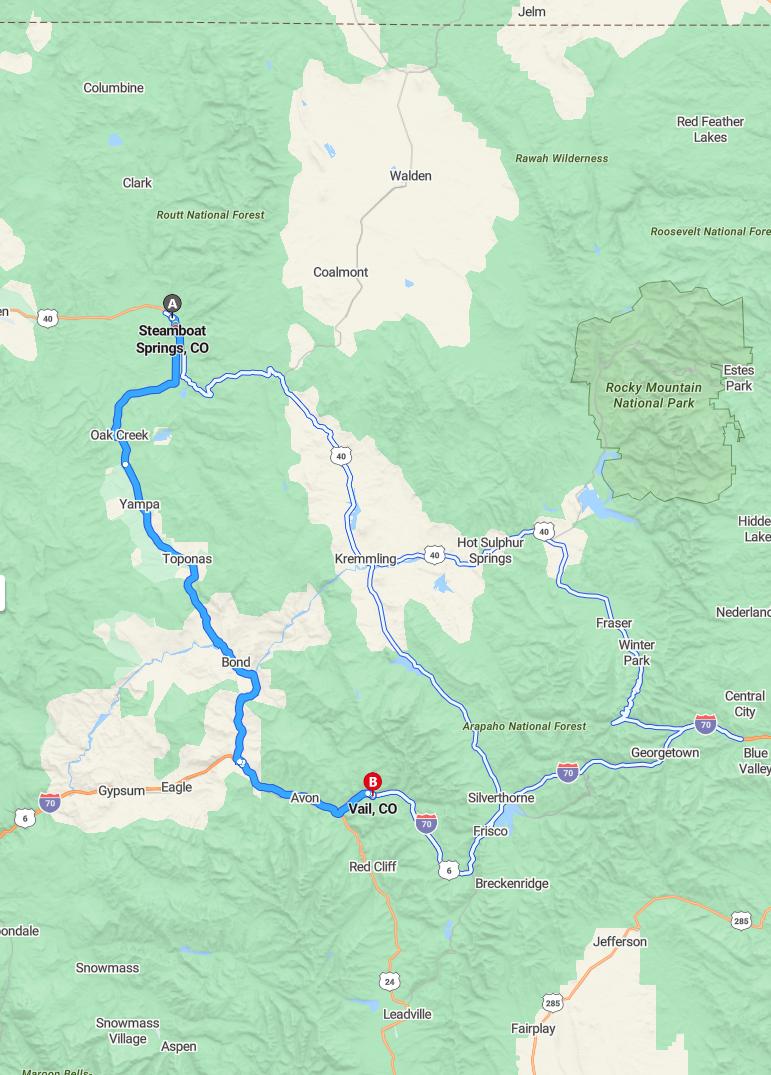
Current Road Condition and Route Map
| Select | Stop Name | Category | Description |
|---|---|---|---|
| Oak Creek | Town / Gas | Historic coal mining town with local diners and fuel stations. | |
| Stagecoach State Park | Point of Interest | Scenic reservoir ideal for a quick photo or a short lakeside walk. | |
| Yampa | Town / Rest Area | The "Gateway to the Flat Tops" with historic charm and public restrooms. | |
| Finger Rock | Point of Interest | A unique geological volcanic plug formation visible from CO-131. | |
| Toponas | Point of Interest | Wide-open ranching country offering expansive mountain photography. | |
| State Bridge | Point of Interest | A historic crossing at the Colorado River with scenic river views. | |
| Wolcott | Gas Station | Crucial junction point with fuel and convenience services before I-70. | |
| Edwards Riverwalk | Point of Interest | Upscale outdoor shopping and dining area along the Eagle River. | |
| Nottingham Park | Point of Interest | Located in Avon; offers a lake, walking paths, and mountain views. | |
| Eagle-Vail | Town / Rest Area | Convenient stop between Avon and Vail for quick errands or coffee. |

Distance and estimated driving time
The drive from Steamboat Springs to Vail covers approximately 93 miles via CO-131 and I-70 East, providing a scenic and efficient route. The estimated travel time is around 1 hour and 45 minutes, making it a manageable trip for travelers seeking to enjoy Colorado's picturesque landscapes. This route offers a combination of mountain views and highway convenience, ideal for both leisure and quick getaways. Planning ahead ensures a smooth journey, whether heading for outdoor adventures or exploring Vail's renowned resorts.
Driving route
Traveling from Steamboat Springs to Vail offers a scenic journey through the Colorado Rockies, beginning in the charming mountain town of Steamboat Springs. As you leave Steamboat, you'll pass through the quaint towns of Oak Creek and Yampa, which are known for their outdoor recreational opportunities and stunning natural landscapes. Continuing south, the route takes you through Toponas and Bond, small communities that provide a glimpse into the local mountain lifestyle. The drive culminates as you arrive in Avon, a vibrant town that serves as a gateway to Vail and the surrounding resorts. Finally, your trip concludes in Vail, renowned for its world-class ski slopes, luxurious accommodations, and picturesque alpine village ambiance.
Scenic attractions along the route
Driving from Steamboat Springs to Vail offers breathtaking scenic attractions at every turn. Visitors can enjoy the picturesque Yampa Valley, renowned for its lush greenery and majestic mountain views. Along the route, Oak Creek and Yampa showcase charming small-town atmospheres surrounded by stunning natural landscapes. The journey culminates with the spectacular vistas of Vail, featuring towering peaks and world-class alpine scenery, making it a truly memorable scenic drive.
Best times to drive for weather conditions
The best times to drive between Steamboat Springs and Vail are during clear, dry weather conditions, typically from late spring through early fall, when snow and ice are less likely to impact travel. If traveling in winter, it is advisable to check local weather reports and road conditions regularly, as winter storms can cause hazardous driving conditions, especially through mountain passes like Toponas and Bond. Early mornings or late afternoons are often preferable to avoid daytime snowmelt or freezing temperatures that may lead to icy roads. Ultimately, planning your trip during mild weather months and staying informed about real-time conditions can ensure a safer and more comfortable journey.
Road safety tips for mountain driving
When driving through mountainous areas like the route from Steamboat Springs to Vail, it's essential to prioritize safety. Always check weather conditions before the trip, as mountain roads can be affected by fog, rain, or snow, reducing visibility and traction. Maintain a safe speed, especially on sharp curves and steep grades, and be prepared for sudden changes in terrain. Additionally, keep your vehicle in good condition, particularly brakes and tires, and carry emergency supplies in case of unforeseen delays or inclement weather.
Parking options in Vail
Vail offers a variety of parking options for visitors, including both on-street and P.E. service parking garages. The Vail Village and Lionshead areas feature multiple structured parking facilities, such as the Vail Village Parking Structure and the Lionshead Parking Deck, providing convenient access to shops, restaurants, and ski lifts. For those planning extended stays, there are several park-and-ride lots equipped with shuttle services, making it easier to navigate the town without worrying about parking fees. Visitors should be aware that parking fees generally apply, but flexible options are available to suit different needs and durations.
Nearby dining and rest stops
Along the route from Steamboat Springs to Vail, travelers can find a variety of dining and rest stops to enhance their journey. In Oak Creek, there are cozy cafes and local eateries perfect for a quick meal or coffee break. Yampa offers charming spots to relax and enjoy regional cuisine, while Toponas features scenic rest areas ideal for stretching your legs. Approaching Avon and finally Vail, visitors will discover numerous restaurants, cafes, and scenic rest spots to refresh before reaching their destination.
Seasonal travel considerations
Traveling from Steamboat Springs to Vail requires careful seasonal planning, as weather conditions can vary significantly throughout the year. During winter months, snow and ice may lead to hazardous driving conditions on mountain passes and roadways, necessitating tire chains and cautious driving. In the summer, seasonal storms can cause road closures or delays, so travelers should check local weather forecasts and road statuses beforehand. Additionally, the region experiences high tourist traffic during peak seasons, so early reservations and flexible schedules can enhance the overall journey.
Traffic conditions and congestion updates
Traveling from Steamboat Springs to Vail, motorists generally experience smooth conditions, especially during weekday mornings and late evenings. However, expect some congestion around Oak Creek and Avon during peak travel times, particularly on weekends and holidays, due to increased holiday traffic and ski crowds. Road conditions can vary in the mountain passes, so it's advisable to check for any current weather-related closures or advisories before departure. Overall, with moderate planning, the route offers a relatively seamless drive, allowing travelers to enjoy the picturesque mountain scenery along the way.
Alternative routes and detours
When traveling from Steamboat Springs to Vail, travelers can consider alternative routes such as taking State Highway 131 through Toponas and Bond, which offers scenic views of the Flat Tops Wilderness Area. Additionally, detours via the Eagle River Valley, connecting through Eagle or Gypsum, provide manageable options if the primary route encounters closures or winter conditions. It's advisable to check current road conditions, especially during inclement weather, as closures or restrictions are common on mountain passes. Exploring these alternatives ensures a safer and more flexible journey while enjoying Colorado's stunning landscapes.

Leave a comment