Current Road Condition and Route Map
| Select | Stop Name | Type | Description |
|---|---|---|---|
| Westley Rest Area | Rest Area | Basic amenities for a quick break south of the I-580/I-5 junction. | |
| San Luis Reservoir | Point of Interest | Scenic overlook and visitor center with views of the massive reservoir. | |
| Harris Ranch | Point of Interest / Food | Famous landmark known for its steakhouse, bakery, and hotel. | |
| Kettleman City | Gas Station / Food | Major hub with numerous fast food options and EV charging stations. | |
| Buttonwillow | Gas Station / Food | Popular pit stop for fuel and quick dining before the Grapevine. | |
| Tejon Ranch Outlets | Point of Interest / Shopping | Large outlet mall with diverse dining options at the base of the mountains. | |
| Fort Tejon State Historic Park | Point of Interest | Historic 1850s army post located at the top of the Grapevine. | |
| Pyramid Lake | Point of Interest | Scenic vista point and visitor center overlooking the reservoir. | |
| Castaic Lake | Point of Interest | Large recreation area perfect for a final stretch break before Sylmar. |

Distance and estimated driving time
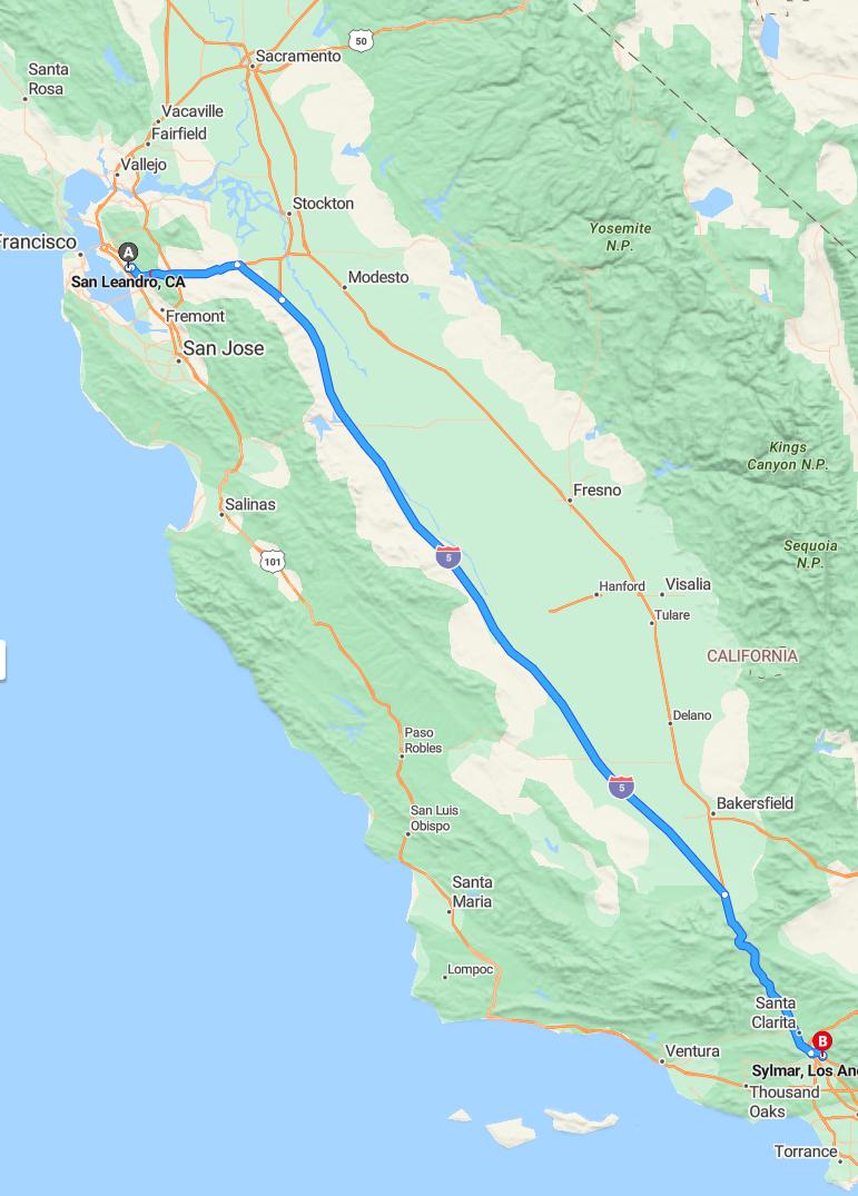
The driving route from San Leandro to Sylmar covers approximately 342 miles and is estimated to take around 4 hours and 41 minutes. Travelers will primarily drive via I-580 East, which connects San Leandro to the I-5 South, leading directly toward Sylmar. This route offers a straightforward path, making it a convenient option for drivers heading southward from the Bay Area to the Los Angeles region. Planning ahead for potential traffic or rest stops can help ensure a smooth and timely journey.
Driving route
The drive from San Leandro to Sylmar takes you through a diverse range of California landscapes and cities. Starting in San Leandro, you head south through Fremont and continue to the bustling city of San Jose, known for its tech industry and vibrant culture. As you progress, you'll pass through Gilroy and King City, then traverse scenic areas around Paso Robles and Santa Maria before reaching Guadalupe and Santa Barbara, renowned for their coastal charm. The route continues along the coast through Ventura and Thousand Oaks, offering stunning ocean views before entering the urban sprawl of Los Angeles and finally arriving in Sylmar. This journey showcases California's varied geography, from urban centers to coastal beauty and rolling inland hills.
Traffic conditions and peak hours
Traveling from San Leandro to Sylmar involves crossing multiple busy areas, with traffic conditions varying throughout the day. Peak hours typically occur between 7:00-9:00 AM and 4:00-7:00 PM, especially around major cities like San Jose, Los Angeles, and Ventura, where congestion can be significant. During these times, delays are common on key highways such as Interstate 680, Highway 101, and the I-5 corridor, particularly near urban centers and during weekend rush hours. To avoid heavy traffic, it's advisable to plan your trip outside of peak times or consider alternative routes, especially through more remote areas like Gilroy and King City.
Alternative routes and detours
When driving from San Leandro to Sylmar, travelers can consider alternative routes such as taking Interstate 580 East through the Dublin-Pleasanton area or connecting via Highway 99 South to avoid Los Angeles traffic. Detours around congested sections, like the Santa Barbara or Ventura areas, may involve exploring smaller highways such as Highway 1 or State Route 33, which offer scenic alternatives. Additionally, considering travel during off-peak hours can help circumvent delays caused by urban congestion. Planning ahead with real-time navigation apps ensures drivers can adapt their route to current road conditions, making the journey smoother and more efficient.
Scenic spots and points of interest along the way
Traveling from San Leandro to Sylmar offers a variety of scenic spots and points of interest. In San Jose, visitors can explore the beautiful Japanese Friendship Garden and the historic Winchester Mystery House. As you continue south, Gilroy is known for its famous garlic farms and the picturesque Gilroy Gardens amusement park. The route through Paso Robles and Santa Maria offers stunning vineyard landscapes and scenic coastal views near Santa Barbara, which boasts beautiful beaches and the historic Santa Barbara Mission. Lastly, driving through Thousand Oaks and into Los Angeles provides access to lush parks like the Santa Monica Mountains and iconic cultural landmarks.
Rest stops and amenities
Traveling from San Leandro to Sylmar offers several convenient rest stops along the route, particularly in major cities such as San Jose, Gilroy, and Santa Barbara. These locations typically feature amenities like fuel stations, restaurants, and clean restroom facilities, providing travelers with opportunities to refresh and refuel. In addition, scenic areas near Paso Robles and Santa Maria may have designated rest areas or parks perfect for a short break and sightseeing. Planning your stops in advance ensures a comfortable journey, allowing you to enjoy the diverse landscapes and attractions along this route while staying well-rested and prepared.
Weather forecast during the drive
During the drive from San Leandro to Sylmar, travelers can expect generally mild weather conditions, with temperatures ranging from cool in the northern areas to warmer in Southern California. In the San Francisco Bay Area, including San Leandro, fog and overcast skies are common in the mornings, gradually giving way to sunshine later in the day. As the route progresses through central California, temperatures tend to increase, especially around Paso Robles and Santa Maria, with mostly clear skies and minimal chances of rain. In the Los Angeles and Sylmar regions, warm and dry conditions are typical, providing a pleasant driving experience with little weather-related disruptions.
Road safety tips and regulations
When driving from San Leandro to Sylmar, it's essential to prioritize road safety by adhering to all traffic laws and regulations. Always wear your seatbelt, obey posted speed limits, and avoid distractions such as cell phone use while driving. Maintain a safe following distance, especially during long stretches through areas like San Jose and Gilroy, where traffic can vary. Additionally, be mindful of weather conditions, stay alert, and follow signs and signals to ensure a safe and smooth journey through diverse regions like Paso Robles, Santa Barbara, and Los Angeles.
Parking options in Sylmar
Sylmar offers a variety of parking options for visitors and residents alike. There are several public parking lots and street parking available throughout the neighborhood, especially near shopping centers and community parks. Additionally, many local businesses provide designated parking spaces, making it convenient for customers. For those attending events or visiting popular attractions, designated event parking and nearby parking garages are also accessible, ensuring a hassle-free experience in Sylmar.
Fuel stations and cost estimates
When driving from San Leandro to Sylmar, it is important to plan for fuel stops along the route through cities like Fremont, San Jose, Gilroy, and others. Fuel prices can vary significantly between regions, with California generally having higher costs compared to neighboring states; expect to pay approximately $4.50 to $5.50 per gallon for regular unleaded. Several fuel stations are available in major towns such as Gilroy, Paso Robles, and Santa Maria, offering convenient refueling options. Based on an average vehicle with a 15-gallon tank and an estimated 300-mile trip, the total fuel cost is projected to be around $70 to $85, depending on current prices and fuel efficiency.

Leave a comment