Current Road Condition and Route Map
| Select | Stop Name | Category |
|---|---|---|
| Treasure Island Viewpoint | Point of Interest | |
| Public Market Emeryville | Rest Area / Food | |
| Berkeley Marina | Point of Interest | |
| Point Richmond Historic District | Point of Interest | |
| Chevron Pinole | Gas Station | |
| Carquinez Bridge Vista Point | Point of Interest | |
| Mare Island | Point of Interest | |
| Gateway Plaza Vallejo | Rest Area / Gas | |
| Six Flags Discovery Kingdom | Point of Interest | |
| Cordelia Junction Antique Mall | Point of Interest |

Distance and estimated driving time
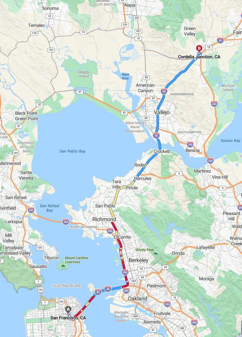
The drive from San Francisco to Cordelia Junction covers approximately 41.3 miles via I-80 E. The estimated travel time for this route is around 1 hour and 5 minutes. This route offers a relatively quick connection between the two locations, making it suitable for both commuting and leisurely trips. To ensure a smooth journey, it is advisable to check real-time traffic conditions before departure.
Driving route
Begin your journey in San Francisco, with a scenic drive through Richmond and Berkeley, both offering vibrant cultural scenes. Continue heading east to El Cerrito and Oakland, bustling cities known for their diverse communities and lively arts. Passing through Pontoon, Richmond again, and San Pablo, you'll experience a mix of urban and suburban landscapes before reaching Crockett and Vallejo. The route then takes you through American Canyon, offering picturesque views before arriving at your final destination, Cordelia Junction. This scenic route showcases the dynamic variation between urban centers and tranquil outskirts, making your drive both interesting and memorable.
Notable landmarks along the route
As you travel from San Francisco to Cordelia Junction, you'll pass several notable landmarks. In San Francisco, scenic views of the city skyline and the iconic Golden Gate Bridge mark the start of your journey. Continuing through Berkeley, the University of California campus offers a vibrant educational atmosphere, while in Oakland, the historic Jack London Square provides a lively waterfront experience. Further along, Vallejo's Naval and Historical Museum and the scenic watersheds near Crockett enrich your trip, culminating at Cordelia Junction, a key transportation hub in the region.
Traffic conditions and peak hours
Traveling from San Francisco to Cordelia Junction typically involves navigating through several busy urban and suburban areas, including Berkeley, Oakland, and Vallejo, where traffic congestion can be significant. Peak hours, generally from 7:00 AM to 9:00 AM and 4:30 PM to 7:00 PM, tend to see increased traffic volume, especially around major interchanges and city centers. During these times, travelers may experience delays, particularly near Richmond, Oakland, and the approaches to Cordelia Junction. To minimize travel time, it is advisable to plan trips outside of peak hours or allow for extra commute time when heading through these heavily trafficked regions.
Road types and highway information
The drive from San Francisco to Cordelia Junction encompasses a variety of road types, starting with urban streets within San Francisco before transitioning onto major highways such as Interstate 80. Traveling through cities like Richmond and Berkeley involves navigating densely populated areas with a mix of surface streets and arterial roads, while driving through El Cerrito and Oakland often requires awareness of local traffic patterns. As you progress toward Vallejo and American Canyon, the route predominantly follows interstate highways designed for efficient long-distance travel, including optional express lanes and controlled-access freeways. This varied highway network ensures a smooth and efficient journey, combining scenic urban routes with high-capacity highways suited for regional transit.
Alternative routes and shortcuts
Travelers heading from San Francisco to Cordelia Junction can explore various alternative routes and shortcuts to save time and improve their journey. One efficient option is to take the Richmond-San Rafael Bridge to bypass downtown traffic, connecting directly to the East Bay area. Additionally, using local side streets through El Cerrito and Berkeley can help avoid congestion on major freeways, especially during peak hours. For those familiar with the area, detours via Crockett and Vallejo may provide quicker access, depending on current traffic conditions and road closures. Planning ahead with real-time navigation apps can help identify the fastest and most scenic routes tailored to specific departure times.
Weather impact on driving conditions
Weather conditions can significantly influence driving safety and comfort along the route from San Francisco to Cordelia Junction. Fog and rain are common in the Bay Area, especially in the mornings and evenings, reducing visibility and making roads more slippery, particularly in urban areas like Berkeley and Oakland. Wind gusts may also affect driving stability, particularly near waterfronts such as Richmond and Vallejo, where open areas can experience stronger currents. Travelers should remain alert to changing weather patterns, adjust their speed accordingly, and ensure their vehicle's safety features are engaged to navigate safely through varying conditions.
Rest stops and parking locations
When driving from San Francisco to Cordelia Junction, there are several convenient rest stops and parking options along the route. In Richmond and Berkeley, public parking garages and street parking provide accessible options for quick breaks. El Cerrito and Oakland offer nearby parks and shopping centers with ample parking for longer rests. As you approach Vallejo and American Canyon, designated rest areas and parking lots at gas stations and commercial areas ensure a comfortable pause before reaching Cordelia Junction.
Safety tips for long-distance driving
When embarking on a long-distance drive from San Francisco to Cordelia Junction, safety should be a top priority. Be sure to rest adequately before starting your journey and take frequent breaks, especially during the segments through busy areas like Oakland, Richmond, and Vallejo, to prevent fatigue. Maintain a safe following distance, adhere to speed limits, and stay alert for traffic conditions or construction zones along the route. Additionally, keep emergency supplies such as water, a first aid kit, and a fully charged phone nearby, ensuring you are prepared for any unexpected situations during your trip.
Local services and amenities en route
Along the route from San Francisco to Cordelia Junction, travelers can enjoy a variety of local services and amenities. In cities like Berkeley, Oakland, and Vallejo, there are numerous restaurants, cafes, and shopping centers to accommodate different preferences. Rest stops and fuel stations are conveniently available in Richmond, San Pablo, and Crockett, ensuring a comfortable journey. Additionally, community centers and public parks in towns such as El Cerrito and American Canyon offer welcoming spaces for relaxation and brief breaks along the way.

Leave a comment