Current Road Condition and Route Map
| Select | Stop Name | Category | Location |
|---|---|---|---|
| Victoria Gardens | Point of Interest | Rancho Cucamonga, CA | |
| California Route 66 Museum | Point of Interest | Victorville, CA | |
| Barstow Station | Rest Area / Food | Barstow, CA | |
| Peggy Sue's 50's Diner | Point of Interest / Food | Yermo, CA | |
| Calico Ghost Town | Point of Interest | Yermo, CA | |
| EddieWorld | Gas Station / Food | Yermo, CA | |
| Mojave National Preserve | Point of Interest | Kelso, CA | |
| Ludlow Gas & Food | Gas Station / Food | Ludlow, CA | |
| Desert Oasis Rest Area | Rest Area | Newberry Springs, CA | |
| Fenner Gas Stop | Gas Station | Fenner, CA |

Distance and estimated driving time
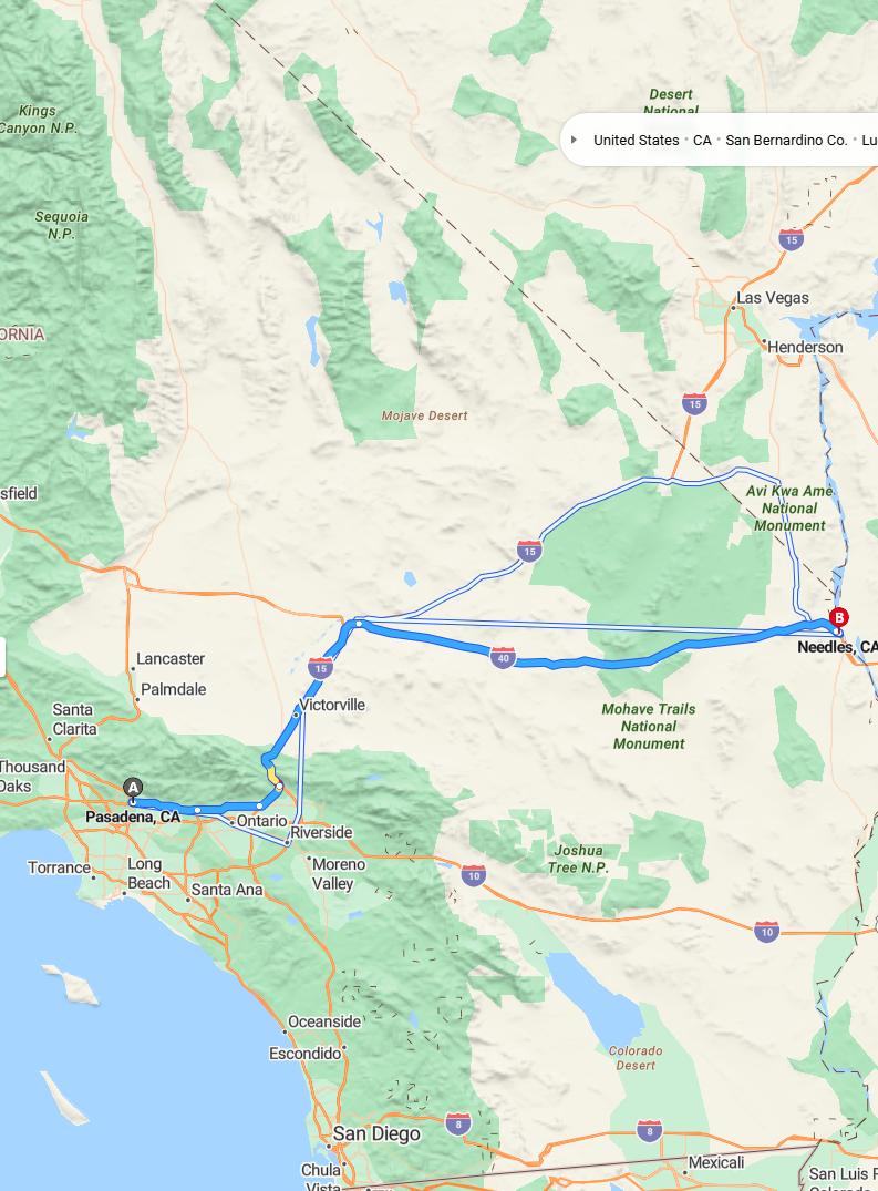
The journey from Pasadena to Needles covers approximately 247 miles via I-15 N and I-40 E. The estimated driving time is around 3 hours and 37 minutes, providing a reasonable travel duration for this route. This highway trip offers scenic views and a straightforward path through California and into the desert regions of California and Arizona. It's advisable to check current road conditions and weather forecasts before departure to ensure a smooth and safe trip.
Driving route
Traveling from Pasadena to Needles offers a scenic journey through Southern California's diverse landscapes. Starting in Pasadena, travelers will pass through Ontario, a vibrant city known for its thriving commerce and cultural attractions. Continuing westward, Riverside provides a glimpse into historical architecture and cultural heritage. As you reach Victorville, the scenery shifts to desert landscapes and expansive open spaces. Finally, arriving in Needles, travelers are greeted by the rugged beauty of the Mojave Desert, completing a route that showcases Southern California's contrasting environments.
Popular attractions along the route
Traveling from Pasadena to Needles offers an exciting journey through diverse attractions. In Ontario, visitors can explore the Ontario Mills mall and the beautiful Ontario Museum of History & Art. Riverside features the historic Mission Inn Hotel & Spa, an architectural gem with rich history, and the Riverside Art Museum. As you pass through Victorville, the California Route 66 Museum provides fascinating insights into historic highway travel, culminating in Needles, where travelers can enjoy the scenic views of the Colorado River and the nearby Havasu National Wildlife Refuge.
Best time to travel
The optimal time to drive from Pasadena to Needles is during the fall and spring seasons, specifically from March to May or September to November, when the weather is generally mild and pleasant. Traveling during early mornings or late afternoons can help you avoid the midday heat and heavy traffic, especially as you approach desert areas like Victorville and Needles. Summer months, from June to August, tend to be extremely hot, making daytime travel less comfortable and potentially hazardous. Winter travel, although cooler, can still be manageable but be prepared for possible early morning fog or rain, particularly in the inland areas along the route.
Road conditions and safety tips
Driving from Pasadena to Needles involves navigating a variety of road conditions along the route, including urban streets, highways, and desert stretches. To ensure safety, drivers should regularly check weather updates, especially for desert areas prone to high temperatures and sudden storms, and be prepared for possible road maintenance or closures. It's important to stay alert, adhere to speed limits, and take frequent breaks to combat fatigue, particularly during long stretches without services. Additionally, carrying sufficient water, emergency supplies, and ensuring your vehicle is in good condition can help prevent issues and promote a safe journey through diverse terrains.
Fuel stops and amenities available
When driving from Pasadena to Needles, travelers can find convenient fuel stops and amenities at several key locations along the route. Ontario and Riverside provide numerous gas stations, restaurants, and rest areas, ensuring drivers can comfortably refuel and refresh. As you continue through Victorville, an array of shopping centers, convenience stores, and service stations are available to meet various needs. Near Needles, options become more limited, so it's advisable to top off supplies beforehand, especially if planning a longer stay or requiring specific services.
Scenic viewpoints and photo spots
As you drive from Pasadena to Needles, you'll encounter several scenic viewpoints and photo spots worth capturing. In Ontario, the vibrant cityscape offers great urban photography opportunities, while Riverside features beautiful Riverside Canyon and botanical gardens that provide lush, picturesque backgrounds. Victorville offers sweeping desert vistas and striking mountain views ideal for panoramic photos. Approaching Needles, the vast Mojave Desert landscape presents dramatic desert scenery and stunning sunsets, perfect for memorable photographs of your journey.
Weather forecast for the drive
The weather forecast for the drive from Pasadena to Needles predicts clear skies and mild temperatures in Pasadena, providing a comfortable start to your journey. As you progress through Ontario, Riverside, and Victorville, the conditions are expected to remain favorable, with minimal chances of rain or adverse weather. Near Needles, especially in the desert region, temperatures may increase significantly, so drivers should prepare for hot conditions. Overall, travelers can anticipate smooth driving conditions throughout the route, but it's advisable to stay updated on local weather alerts, particularly for high temperatures near Needles.
Local dining options and rest areas
While traveling from Pasadena to Needles, travelers can enjoy a variety of local dining options in cities like Ontario, Riverside, and Victorville, where restaurants offer diverse cuisines, including American, Mexican, and Asian dishes. Rest areas along the route provide convenient spots for stretching, refueling, and quick breaks, ensuring a comfortable journey. In Riverside and Victorville, travelers also have access to park facilities and picnic areas, perfect for a leisurely pause. Overall, the route offers ample opportunities to enjoy local flavors and rest conveniently during the drive.
Travel regulations and vehicle requirements
When traveling from Pasadena to Needles along this route, travelers should ensure their vehicle complies with California and interstate travel regulations. It is essential to carry valid driver's licenses, registration, and proof of insurance, as these are mandatory for legal driving across state lines. Additionally, since the route passes through diverse regions, drivers should check for any specific vehicle requirements such as emissions testing or safety inspections, particularly if traveling with commercial vehicles. Planning ahead for potential weather changes or road conditions can also help ensure a safe and smooth journey through cities like Riverside and Victorville before reaching Needles.

Leave a comment