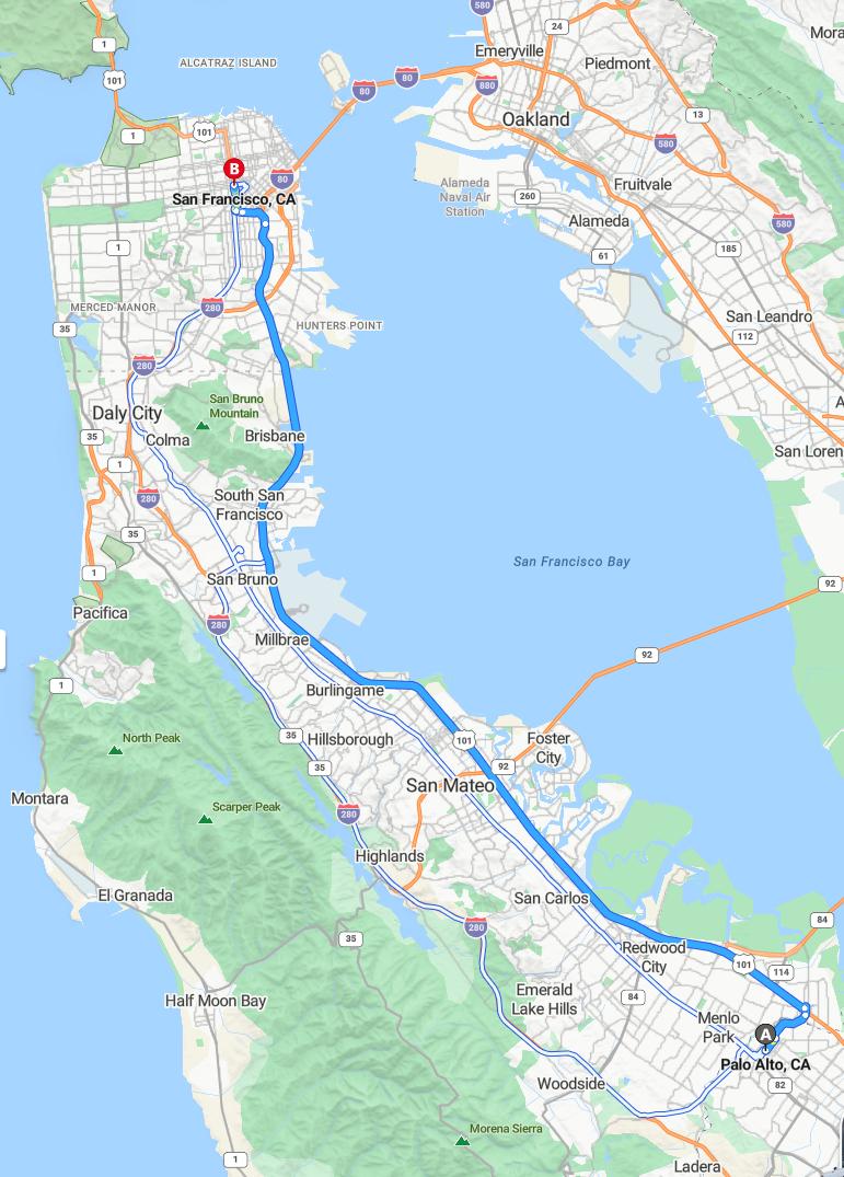
Current Road Condition and Route Map
| Select | Stop Name | Type | Location |
|---|---|---|---|
| Meta Headquarters Sign | Point of Interest | Menlo Park | |
| Hiller Aviation Museum | Point of Interest | San Carlos | |
| Pulgas Water Temple | Point of Interest | Redwood City | |
| Coyote Point Recreation Area | Point of Interest / Park | San Mateo | |
| SFO Cell Phone Waiting Lot | Rest Area / Gas Station | San Bruno | |
| South SF Sign Viewpoint | Point of Interest | South San Francisco | |
| Oyster Point Park | Rest Area / Park | South San Francisco | |
| Candlestick Point | Point of Interest | San Francisco | |
| Chase Center | Point of Interest | San Francisco | |
| Oracle Park | Point of Interest | San Francisco |
Distance and estimated driving time
The drive from Palo Alto to San Francisco typically takes approximately 0.65 hours, covering a distance of about 33.1 miles. The most common route is via US-101 North, which provides a direct and efficient path between the two locations. Traffic conditions may vary, so it is advisable to check real-time updates before departure. This route is popular for commuters traveling between Silicon Valley and the city of San Francisco, ensuring a relatively swift journey.
Driving route
The drive from Palo Alto to San Francisco offers a scenic journey through several vibrant neighborhoods and cities along the California coast. Starting in Palo Alto, you'll pass through Menlo Park, known for its tech hubs and historic sites, before reaching Redwood City with its lively downtown. Continuing along the route, San Carlos and San Mateo provide charming communities with parks and shopping districts, while Hillsborough presents upscale neighborhoods. As you approach San Francisco, you'll traverse Burlingame, Millbrae, and South San Francisco, each offering unique attractions and eateries. Finally, arriving in San Francisco, you'll be immersed in its iconic sights, diverse culture, and bustling city life.
Traffic conditions and peak hours
Driving from Palo Alto to San Francisco typically involves navigating through several traffic-intensive areas, especially during peak hours. The most congested times are usually weekday mornings from 7:00 to 9:00 a.m. and late afternoons from 4:00 to 6:30 p.m., when commuters travel between these cities. Areas like Menlo Park, Redwood City, and South San Francisco often experience heavy traffic, leading to potential delays. To avoid congestion, travelers should consider alternative routes or plan their trips outside these peak periods.
Alternative routes for faster travel
For a faster commute from Palo Alto to San Francisco, consider alternative routes such as taking Highway 101 directly north through Menlo Park, Redwood City, and Burlingame, which often offers smoother traffic flow during peak hours. Alternatively, utilizing the Caltrain line from Palo Alto to San Francisco can bypass highway congestion entirely and provide a reliable, quicker option. Another option is to use the Bayshore Freeway, especially during off-peak times, as it tends to be less congested than surface streets. Finally, checking live traffic updates and planning your trip during off-peak hours can significantly reduce travel time regardless of the route taken.
Public transportation options between Palo Alto and San Francisco
Travelers between Palo Alto and San Francisco have several public transportation options. The Caltrain offers a convenient and efficient commuting service, with frequent trains running along the Peninsula, stopping at key stations such as Menlo Park, Redwood City, San Mateo, and Millbrae before reaching San Francisco. Additionally, SamTrans buses provide comprehensive coverage along the route, connecting Palo Alto to various neighborhoods and transit hubs. For those seeking faster routes, the San Francisco International Airport (SFO) Transit Center and BART station, accessible via Caltrain and buses, enable seamless regional travel.
Parking availability and tips in San Francisco
Parking in San Francisco can be challenging due to limited spaces and high demand, so planning ahead is essential. Street parking is often limited to a specific timeframe and requires meters or residential permits, so it's best to use parking apps to find available spots and pay conveniently. Alternatively, designated parking garages and lots are available throughout the city, offering secure and reliable options, sometimes at affordable hourly rates. For added convenience, consider using public transportation or ride-sharing services to navigate the city without the hassle of parking navigating city streets.
scenic spots and sightseeing along the route
Traveling from Palo Alto to San Francisco offers a variety of scenic spots and attractions along the route. In Menlo Park, visitors can explore the beautiful Stanford University campus, renowned for its stunning architecture and landscaped gardens. Redwood City features the picturesque downtown waterfront, perfect for leisurely strolls and dining with views of the harbor. As you approach San Francisco, the route passes through Hillsborough and Burlingame, where lush neighborhoods and coastal views provide delightful sightseeing opportunities before reaching the vibrant cityscape of San Francisco.
Cost of tolls and fees for different routes
When driving from Palo Alto to San Francisco, the tolls and fees vary depending on the chosen route. The primary route via the US-101 and I-280 typically incurs tolls on the larger bridges, such as the San Mateo-Hayward Bridge and the San Francisco-Oakland Bay Bridge, with toll costs ranging from $7 to $8 during peak hours. Alternative routes through surface streets like El Camino Real generally avoid tolls but may involve increased travel time due to traffic congestion. It is advisable for drivers to consider electronic toll payment systems like FasTrak to streamline crossings and potentially benefit from discounted rates.
Safety tips for driving in urban areas
When driving in urban areas like Palo Alto and San Francisco, it's essential to stay vigilant and adhere to traffic laws to ensure safety. Always keep a close eye on pedestrians, cyclists, and other vehicles, especially at intersections and crosswalks. Maintain a safe following distance and avoid distractions such as mobile phones to prevent accidents. Additionally, be prepared for sudden stops, parking restrictions, and one-way streets, which are common in busy city environments.
Recommended travel times for avoiding congestion
To avoid traffic congestion when driving from Palo Alto to San Francisco, it is best to travel early in the morning before 7:00 AM or later in the evening after 7:00 PM. During weekday rush hours, typically between 7:30 AM to 9:30 AM and 4:00 PM to 7:00 PM, the commute can be significantly more congested, especially through cities like Menlo Park, Redwood City, and Millbrae. Traveling during midday hours, around 11:00 AM to 1:30 PM, generally offers smoother traffic flow. Planning your trip outside of peak times can help ensure a quicker, more relaxed journey along this route.

Leave a comment