Current Road Condition and Route Map
| Select | Stop Name | Type |
|---|---|---|
| Nut Tree Plaza (Vacaville) | Point of Interest / Food | |
| UC Davis Arboretum | Point of Interest | |
| Old Sacramento Waterfront | Point of Interest | |
| Granzella's (Williams) | Point of Interest / Food | |
| The Olive Pit (Corning) | Point of Interest | |
| Sundial Bridge (Redding) | Point of Interest | |
| Shasta Lake Vista Point | Rest Area / POI | |
| Hedge Creek Falls (Dunsmuir) | Point of Interest | |
| Castle Crags State Park | Point of Interest | |
| Black Bear Diner (Mount Shasta) | Gas Station / Food |

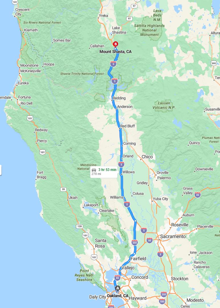
Distance and estimated driving time
The drive from Oakland to Mount Shasta covers approximately 270 miles via I-80 East and I-5 North. The journey typically takes around 3 hours and 54 minutes, depending on traffic conditions. Travelers can enjoy scenic views along the route, especially as they approach Mount Shasta. It's advisable to check for real-time traffic updates to ensure a smooth and timely trip.
Driving route
Embarking on a journey from Oakland to Mount Shasta offers a scenic drive through diverse Californian landscapes. Starting in Oakland, you'll pass through cities like Vallejo, Fairfield, and Concord, each with unique attractions. Continuing north, the route takes you through charming towns such as Santa Rosa, Ukiah, and Lakeport, offering beautiful views of lakes and forests. As you approach Mount Shasta, destinations like Redding, Lake Shasta, and Paradise highlight the region's natural beauty and outdoor recreation opportunities. This drive provides travelers with a memorable experience, blending urban sites with breathtaking wilderness along the way.
Best time to travel and weather conditions
The best time to travel from Oakland to Mount Shasta is during late spring (May to June) or early fall (September to October) when weather conditions are generally favorable. During these months, travelers can expect mild temperatures and less precipitation, making the journey more comfortable and scenic. Summer months (July and August) are warmer but can bring higher traffic and occasional heatwaves, especially in the inland regions like Redding and Lake Shasta. Winter travel (December to February) may pose challenges due to snow and icy roads in higher elevations near Mount Shasta, so it's advisable to check weather forecasts and road conditions before embarking on this route.
Road conditions and potential closures
Traveling from Oakland to Mount Shasta, drivers should stay informed about current road conditions and potential closures, especially during winter months when snow and ice can impact travel through northern California. Mountain passes such as those near Lake Shasta and the Siskiyou region are prone to sudden weather-related closures, so checking real-time updates is crucial. Landslides and flooding can also affect routes around Vallejo, Fairfield, and Chico, particularly after heavy rain. Planning ahead and remaining flexible with your itinerary will ensure a safer journey through this scenic yet occasionally unpredictable route.
Points of interest along the route
Traveling from Oakland to Mount Shasta offers a scenic journey through diverse California landscapes, with notable points of interest along the way. In Vallejo, visitors can explore the historic Mare Island Naval Shipyard Museum, while Fairfield offers the Suisin City Marina and Pacific Union College Observatory. The route through Santa Rosa and Ukiah provides access to vibrant wineries and beautiful vineyards, perfect for wine enthusiasts. As travelers approach Lakeport and Clearlake, they can enjoy picturesque lakeside views and outdoor activities, culminating with the stunning natural beauty of Lake Shasta and Mount Shasta itself.
Rest stops and amenities available
Travelers driving from Oakland to Mount Shasta will find several rest stops along the scenic route, offering comfort and convenience. Cities like Vallejo, Fairfield, and Concord provide numerous amenities, including gas stations, restaurants, and public restrooms, making breaks easy and comfortable. Smaller towns such as Ukiah, Lakeport, and Williams also feature convenient rest areas with basic facilities for travelers to stretch and refuel. Overall, the route offers a variety of options to ensure a pleasant and well-supported journey through Northern California's beautiful landscapes.
Scenic viewpoints and photo opportunities
Traveling from Oakland to Mount Shasta offers numerous picturesque viewpoints and photo opportunities along the route. In Vallejo and Fairfield, you can capture scenic river vistas, while Concord and Walnut Creek provide charming urban landscapes framed by nearby hills. Heading north, Santa Rosa and Ukiah present stunning vineyard and mountain backdrops perfect for photography, followed by Lakeport and Clearlake, which boast serene lake views and waterfront scenes. Finally, the journey culminates at Mount Shasta, where majestic mountain vistas and expansive sky views create unforgettable photo moments.
Traffic updates and travel advisories
Travelers heading from Oakland to Mount Shasta should stay informed about current traffic conditions and potential advisories along the route. Expect possible delays in urban areas such as Vallejo, Fairfield, and Concord due to ongoing construction projects and peak-hour congestion. Additionally, rural sections near Lakeport, Clearlake, and Mount Shasta may experience variable road conditions, especially during adverse weather. It is advisable to check real-time traffic updates before departure to ensure a smooth journey and to plan for possible diversions or stops along the way.
Vehicle preparation and safety tips
Before embarking on a long road trip from Oakland to Mount Shasta, ensure your vehicle is properly prepared by checking critical systems such as the brakes, tires, and fluid levels. Regular maintenance, including oil changes and tire pressure adjustments, can prevent breakdowns and improve fuel efficiency. It's important to carry an emergency kit with essentials like a first aid kit, flashlight, water, and snacks, especially when traveling through remote areas like Lake County and Northern California. Finally, stay alert and drive attentively, adhering to speed limits and road signs to ensure a safe and enjoyable journey through scenic destinations like Redding, Lake Shasta, and Mount Shasta.
Alternative routes and detours
When driving from Oakland to Mount Shasta, travelers can consider alternative routes and detours to enhance their journey or avoid congestion. One option is to take Highway 29 through Vallejo, Napa, and Calistoga before heading north, providing scenic views and potential bypasses of urban areas. Alternatively, detouring through Clearlake and Lakeport offers a more inland route that may be beneficial during high traffic periods along the main highway. It's advisable to check current road conditions and closures, especially in the Sierra Nevada region, to select the most efficient and safest alternative routes for your trip.

Leave a comment