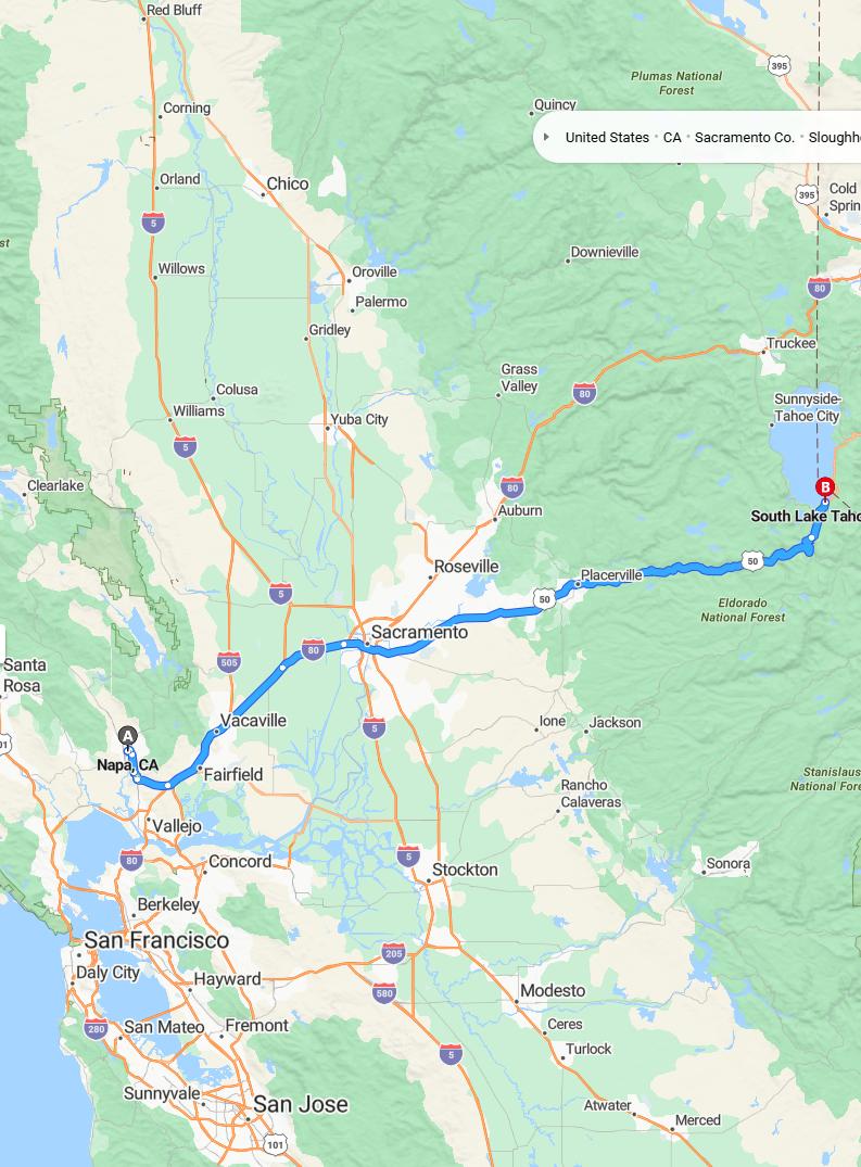
Distance and estimated driving time
The drive from Napa to South Lake Tahoe covers approximately 160 miles via I-80 E and US-50 E. The estimated travel time is around 2 hours and 43 minutes, making it a manageable trip for travelers eager to explore the scenic mountain destination. This route offers a picturesque journey through California's diverse landscape, blending urban areas with natural beauty. Planning your trip with these estimates ensures a smooth and enjoyable adventure to South Lake Tahoe.
Driving route
Embarking on a scenic drive from Napa to South Lake Tahoe offers travelers a diverse and picturesque journey. The route begins in Napa, renowned for its world-class wineries and vineyards, providing a charming start with opportunities for wine tasting and local cuisine. As you head through Vallejo and Sacramento, you'll experience a blend of urban attractions and cultural sights, including historic districts and vibrant city life. Continuing towards Placerville, the landscape shifts to lush forests and rolling hills, setting the stage for the final leg towards South Lake Tahoe. The drive culminates in a stunning alpine destination where crystal-clear waters and mountain scenery invite outdoor recreation and relaxation.

Best time to travel
The best time to travel from Napa to South Lake Tahoe is during the late spring and early fall months, specifically from April to June and September to October, when the weather is mild and the scenic views are particularly stunning. Traveling during weekdays can help avoid heavy weekend traffic, especially around major towns like Vallejo, Sacramento, and Placerville. Summer months (July and August) are popular but tend to be busier with tourists and vacationers, which can lead to delays. Winter travel (November to March) offers picturesque snowy landscapes, but road conditions may require extra caution and up-to-date vehicle preparedness.
Road conditions and weather updates
Travelers driving from Napa to South Lake Tahoe can expect generally favorable road conditions along the route, which passes through Vallejo, Sacramento, and Placerville. However, weather updates indicate potential snowfall and icy patches near South Lake Tahoe, especially during early mornings and evenings, so caution is advised. It's recommended to check current road closures and weather alerts before departure, as winter conditions can impact travel safety. Staying informed through local traffic and weather reports will ensure a smoother and more secure journey.
Traffic congestion and delays
Traveling from Napa to South Lake Tahoe often involves navigating through several busy areas, which can lead to traffic congestion and delays. Major cities such as Vallejo and Sacramento are known for their frequent traffic jams, particularly during peak hours, adding to overall travel time. Additionally, seasonal factors and holiday weekends tend to increase congestion along routes through Placerville and the surrounding mountain areas. It's advisable to plan ahead, check live traffic updates, and consider alternative routes to minimize delays on this scenic drive.
Scenic spots along the way
As you drive from Napa to South Lake Tahoe, you'll encounter a variety of scenic spots that showcase California's diverse beauty. Beginning in Napa, enjoy picturesque vineyards and rolling hills that define the region's renowned wine country. Continuing through Vallejo and Sacramento, the generous views of the Sacramento River and lush green parks offer refreshing landscapes. As you reach Placerville and ascend toward South Lake Tahoe, you'll be treated to stunning mountain vistas, dense forests, and sparkling lake views that make the journey truly breathtaking.
Essential travel tips and safety advice
When driving from Napa to South Lake Tahoe, it is important to plan ahead and check road conditions, especially during winter months when snow and ice can affect safety. Ensure your vehicle is in good condition, with tires suitable for changing weather, and carry emergency supplies such as blankets, water, and a flashlight. Besides adhering to posted speed limits and traffic laws, remain vigilant for sudden weather changes or wildlife crossings, particularly in mountain areas around Placerville and South Lake Tahoe. Lastly, take breaks at designated rest areas along the route through Vallejo, Sacramento, and Placerville to stay alert and reduce fatigue during your journey.
Parking options in South Lake Tahoe
South Lake Tahoe offers a variety of parking options to accommodate visitors, including large public parking lots and garages near popular destinations like the gondola and beaches. Street parking is generally available, with metered spots and designated areas that provide convenient access to shopping, dining, and outdoor activities. For those staying in the area, many hotels and resorts offer on-site parking or valet services for added convenience. Additionally, there are several parking areas in nearby recreational sites, making it easy to explore the natural beauty and entertainment options throughout South Lake Tahoe.
Nearby attractions and activities
As you drive from Napa to South Lake Tahoe, you'll pass through several vibrant cities offering a variety of attractions. In Sacramento, explore the historic Old Sacramento district, visit the California State Railroad Museum, or enjoy the lively waterfront waterfront parks. Vallejo provides opportunities to learn at the Six Flags Discovery Kingdom amusement park or explore marine life at the Mare Island Historic Park Foundation. Approaching Placerville and South Lake Tahoe, outdoor enthusiasts can hike in the El Dorado National Forest, enjoy the scenic beauty of Lake Tahoe, or partake in winter sports such as skiing and snowboarding during the season.
Travel accessories and vehicle preparation
When preparing for a road trip from Napa to South Lake Tahoe, it's essential to gather useful travel accessories such as a GPS device or printed maps, charging cables, and comfortable travel pillows for a more enjoyable journey. Ensuring your vehicle is well-prepared involves checking tire pressure, fluid levels, and brake functionality, especially since the route passes through diverse terrains like Vallejo, Sacramento, and Placerville. Packing a roadside emergency kit with essentials like jumper cables, a flashlight, and basic tools can provide peace of mind during unforeseen situations. Additionally, bringing snacks, water, and entertainment can keep passengers comfortable and alert throughout the scenic drive.
