Current Road Condition and Route Map
| Select | Stop Name | Category | Description |
|---|---|---|---|
| Nut Tree Plaza | Point of Interest | Famous roadside stop with shopping, dining, and a small train for kids. | |
| UC Davis Arboretum | Point of Interest | Beautiful walking paths and gardens near the university campus. | |
| Old Sacramento Waterfront | Point of Interest | Historic district with Gold Rush-era buildings, museums, and river views. | |
| Ikeda's Market | Food / Point of Interest | Local favorite in Auburn known for fresh pies, produce, and burgers. | |
| Gold Run Rest Area | Rest Area | Convenient highway rest stop for restrooms and a quick break. | |
| Emigrant Gap Lookout | Point of Interest | Scenic vista point offering breathtaking views of the Sierra Nevada. | |
| Nyack Shell & Food | Gas Station / Food | High-altitude fuel stop with a Burger King and convenience store. | |
| Cisco Grove Store | Gas Station | Last-minute supplies and fuel before the final climb to the summit. | |
| Donner Memorial State Park | Point of Interest | Museum and park detailing the history of the Donner Party and local lake access. | |
| Historic Downtown Truckee | Point of Interest | Charming mountain town center with boutique shops and local eateries. |

Distance and estimated driving time
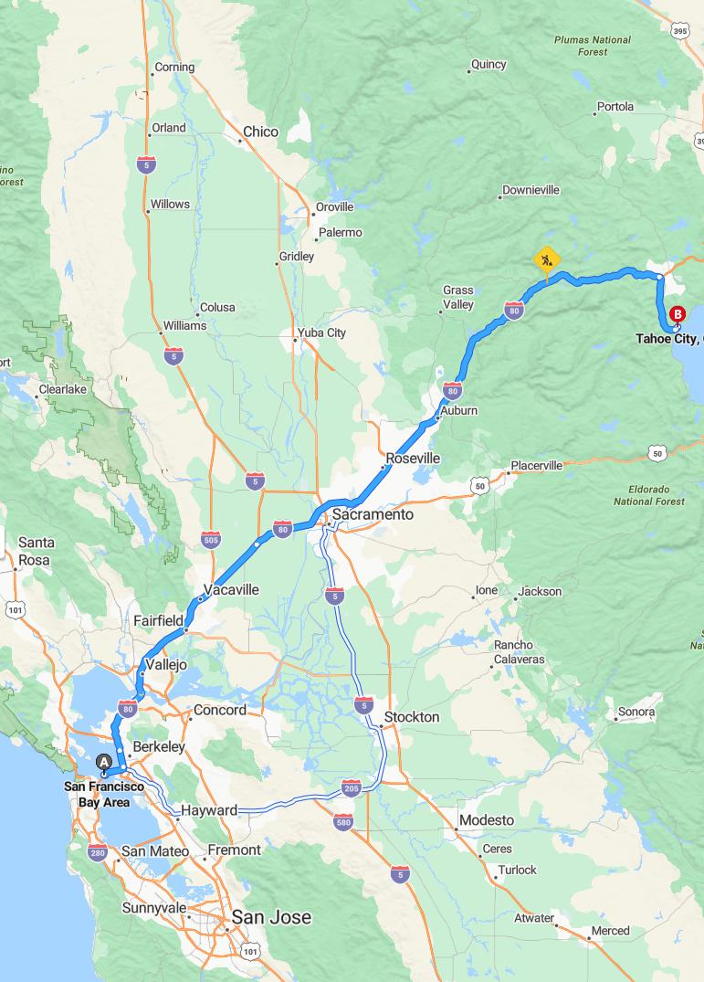
Driving from the Bay Area to Tahoe typically takes approximately 3 hours and 2 minutes, covering a distance of around 195 miles. The most common route is via I-80 East, which offers a direct and efficient path to the Sierra Nevada destination. Travelers can expect a scenic drive with potential seasonal weather considerations, especially during winter months. Planning ahead for possible traffic or weather delays can ensure a smooth and enjoyable trip to Tahoe.
Driving route
The journey from the Bay Area to Tahoe encompasses a diverse array of cities and scenic spots, starting from bustling urban centers like San Francisco, Oakland, and Berkeley, and passing through vibrant suburbs such as Fremont, Sunnyvale, and San Jose. As travelers drive northeast, they traverse cities like Stockton, Modesto, and Merced, offering a glimpse into California's agricultural heartland. The route continues through smaller towns such as Ceres, Turlock, and Atwater, gradually transitioning from valley plains to the foothills of the Sierra Nevada. Approaching Tahoe, visitors may route through Sacramento, known as California's capital, and other charming municipalities like Roseville and Auburn, making the journey not just a commute but a scenic adventure into California's diverse landscape. Overall, this route highlights the rich urban, suburban, and natural environments that define California's central region.
Best time to travel from Bay Area to Tahoe
The best time to travel from the Bay Area to Tahoe is during the late spring (May to June) and early fall (September to October) when weather conditions are generally mild, and the roads are less congested. Summer months (July and August) offer warm weather ideal for outdoor activities, but they tend to be crowded and more expensive due to peak tourist season. Winter travel (December to February) is perfect for skiing and snowboarding lovers but requires preparedness for snow chains and winter conditions. Planning your trip during weekdays and avoiding major holiday weekends can also help ensure a smoother, more enjoyable journey.
Weather conditions during the drive
During the drive from the Bay Area to Tahoe, travelers may experience varying weather conditions along the route. Coastal areas such as San Francisco, Oakland, and Berkeley generally enjoy mild temperatures with partly cloudy or foggy mornings, especially in the spring and fall. As the journey moves inland toward Stockton, Modesto, and further into the Sierra Nevada region, temperatures tend to rise, with clear skies and dry conditions typical of summer months, though occasional thunderstorms can occur in the mountains. In higher elevations around Tahoe, drivers should anticipate cooler temperatures, potential snowfall in winter, and sudden weather changes that require careful navigation and preparedness.
Road conditions and construction updates
Road conditions along the route from the Bay Area to Tahoe are generally smooth, but travelers should be aware of ongoing construction projects in key areas such as Stockton, Modesto, and the outskirts of Sacramento, which may cause temporary delays. Maintenance work and road repairs are scheduled periodically, particularly during off-peak hours, so it's advisable to check for real-time updates before departure. Weather conditions can also impact driving, especially through mountain passes near Tahoe, where snow and ice may lead to road closures or require chain restrictions. For the most accurate and current information, travelers are encouraged to consult local transportation departments and traffic news sources before embarking on their journey.
Scenic spots and viewpoints along the route
As you travel from the Bay Area to Tahoe, you'll encounter numerous scenic spots and viewpoints that highlight the region's natural beauty. In Berkeley, the Claremont Canyon provides stunning panoramic views of San Francisco and the bay, while the hills around San Mateo offer picturesque vistas of the Santa Cruz Mountains. As you approach Stockton, the expansive vistas of the Great Valley can be enjoyed from the top of Lodi Lake, and the scenic delta views near Walnut Grove showcase California's waterways. Once in the Sierra Nevada foothills, viewpoints at Auburn State Recreation Area, including Mount Ashland, offer breathtaking scenes of rolling hills and rugged terrain leading up to Tahoe's alpine splendor.
Recommended stops and break points
When driving from the Bay Area to Tahoe, it's advisable to plan several stops for rest and sightseeing. Consider taking breaks in Stockton or Modesto for refreshments and stretching, as these cities offer convenient amenities and fuel stations. Further along, Sacramento serves as an excellent halfway point to relax, refuel, and enjoy local attractions. Additionally, stopping in Auburn near the Sierra Nevada foothills provides a scenic break before reaching your final destination, ensuring a safer and more enjoyable trip.
Vehicle requirements and safety tips
When preparing for a road trip from the Bay Area to Tahoe, it is essential to ensure your vehicle meets all safety requirements, including current registration, valid insurance, and functioning lights and brakes. Regular maintenance such as checking tire pressure, oil levels, and fluid supplies can help prevent breakdowns during the journey. Additionally, carrying emergency essentials like a first aid kit, blankets, water, and a flashlight enhances safety in case of unexpected stops. Lastly, practicing safe driving habits--obeying speed limits, avoiding distractions, and staying alert--ensures a smooth, secure trip through the diverse terrains along the route.
Travel cost estimates and toll information
Traveling from the Bay Area to Tahoe involves several cost considerations, including fuel, tolls, and potential vehicle wear and tear. Tolls are primarily encountered on bridges such as the San Francisco-Oakland Bay Bridge and the other bridges connecting various cities along the route, with fees varying depending on the time of day and vehicle type. Fuel expenses can also add up given the length of the drive, especially if you choose to make stops in cities like Sacramento and Stockton along the way. To manage costs effectively, travelers should plan ahead by checking current toll rates and fuel prices, potentially using toll pass options or alternative routes when applicable.
Alternative routes and detour options
When traveling from the Bay Area to Tahoe, drivers can consider alternative routes to avoid traffic congestion or construction. One option is to take Interstate 80 East through Oakland, Berkeley, Vallejo, and into Sacramento, which offers scenic views and multiple rest stops. Alternatively, detours through Highway 50 provide access via Placerville and other mountain towns, especially during peak holiday seasons or closures on I-80. It is advisable to check real-time traffic updates and road conditions beforehand, as these detour options can vary in travel time depending on weather and traffic. Having a GPS navigation app on hand can help identify the fastest route and alert travelers to any unexpected delays or closures.

Leave a comment