Current Road Condition and Route Map
| Select | Stop Name | Category | Description |
|---|---|---|---|
| Rock Springs Cafe | Gas / Food | Famous for homemade pies and a historic general store. | |
| Sunset Point Rest Area | Rest Area | Offers panoramic views of the Bradshaw Mountains and Hassayampa River Canyon. | |
| Arcosanti | Point of Interest | An experimental urban laboratory focused on innovative architecture and ecology. | |
| Montezuma Castle | Point of Interest | Well-preserved ancient Sinagua cliff dwellings built into limestone cliffs. | |
| Out of Africa Wildlife Park | Point of Interest | Wildlife preserve offering safari tours and predator shows. | |
| Cliff Castle Casino | Gas / Rest Area | Convenient stop for fuel, dining, and restrooms in Camp Verde. | |
| Bell Rock Pathway | Point of Interest | Scenic red rock views and hiking just off the main highway shortcut. | |
| Montezuma Well | Point of Interest | A natural limestone sinkhole with prehistoric ruins and unique ecology. | |
| V Bar V Heritage Site | Point of Interest | The largest and best-preserved petroglyph site in the Verde Valley. | |
| Munds Park | Gas / Food | Final mountain community before Flagstaff, ideal for a quick coffee or fuel. |

Distance and estimated driving time
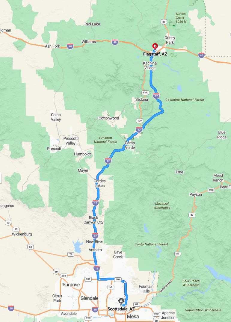
Driving from Scottsdale to Flagstaff typically takes around 2 hours and 12 minutes, covering approximately 153 miles via the I-17 North route. This scenic drive offers travelers a convenient and efficient way to reach their destination while enjoying picturesque Arizona landscapes. To ensure a smooth journey, it is advisable to check current road conditions and weather updates before departing. Whether heading north for leisure or business, this route provides a reliable connection between the two vibrant cities.
Driving route
Embarking on a scenic drive from Scottsdale to Flagstaff, travelers will pass through a diverse array of Arizona's vibrant communities and natural landscapes. The journey begins in Scottsdale and moves through Mesa, Apache Junction, and Chandler, showcasing metropolitan expansion, before reaching Glendale and Surprise, which highlight suburban growth. Continuing north, the route traverses through Black Canyon City, Cordes Lakes, Mayer, Prescott, and Prescott Valley, offering picturesque mountain views and charming towns, before ascending into the forested areas near Williams and Ash Fork. As the drive approaches Flagstaff, travelers can enjoy iconic stops at Sunset Crater and Seligman, enhancing the experience with volcanic landscapes and Route 66 nostalgia. This route provides a compelling blend of urban, historical, and natural attractions, making it an ideal trip for exploring northern Arizona's diverse environment.
Best time to depart for optimal travel conditions
For optimal travel conditions from Scottsdale to Flagstaff, it is best to depart early in the morning, around sunrise, to avoid peak traffic and daytime heat. Traveling in the spring or fall offers mild weather and clearer roads, making for a more comfortable drive. Avoiding holiday weekends and peak vacation seasons helps prevent heavy traffic and delays along the route. Planning your departure considering weather forecasts and local road conditions ensures a smoother journey through scenic areas like Sunset Crater and Williams.
Notable landmarks and scenic viewpoints along the route
Traveling from Scottsdale to Flagstaff offers a scenic journey filled with notable landmarks and breathtaking viewpoints. Along the route, travelers can appreciate the stunning Black Canyon City and the picturesque Sunset Crater, renowned for its unique volcanic landscape. The route also takes you through Prescott and Prescott Valley, where charming historic sites and mountain vistas await. As you approach Flagstaff, the scenic vistas of the San Francisco Peaks and the historic Route 66 highlights make this drive truly memorable.
Road conditions and potential hazards
Driving from Scottsdale to Flagstaff involves traversing a diverse range of road conditions, typical of a mountainous and desert environment. Motorists should be cautious of possible sudden changes in weather, such as rain or snow, especially near higher elevations like Prescott and Williams, which can cause slick or icy roads. Additionally, travelers may encounter wildlife crossings, especially in rural or less-populated areas like Black Canyon City, Mayer, and Ash Fork, posing potential hazards. Road construction or maintenance may also be present, so it's advisable to stay informed about current conditions and plan for delays on this scenic route.
Traffic updates and congestion tips
When driving from Scottsdale to Flagstaff, it's important to stay informed about current traffic conditions, as congestion can vary significantly along the route. Typically, rush hour traffic is heaviest around Mesa, Chandler, and Glendale, so planning your departure outside peak hours can save time. Construction and road maintenance may also cause delays near Black Canyon City and in Prescott Valley, so utilizing real-time traffic apps is recommended. To ensure a smooth trip, consider alternative routes through less congested areas like Anthem and Mayer, and allow extra travel time during weekends or holiday weekends when tourist traffic peaks.
Nearby amenities and rest stops
Travelers driving from Scottsdale to Flagstaff will find numerous amenities and rest stops along the route, ensuring a comfortable journey. Major towns such as Mesa, Chandler, and Glendale offer a wide range of restaurants, gas stations, and shopping centers for refueling and refreshment. Smaller communities like Prescott and Williams provide charming local cafes and scenic spots to relax and enjoy the surroundings. Additionally, designated rest areas and scenic viewpoints near Black Canyon City and Sunset Crater National Monument allow travelers to stretch their legs while taking in breathtaking views of the Arizona landscape.
Weather forecast during the drive
During the drive from Scottsdale to Flagstaff, travelers can expect variable weather conditions. In the lower elevations such as Scottsdale, Mesa, and Chandler, daytime temperatures are typically warm and mild. As you ascend into higher elevations near Prescott, Williams, and Flagstaff, cooler temperatures and possible snow or rain are likely, especially in the early mornings and evenings. It's advisable to check current weather forecasts before departing to ensure proper attire and safe driving conditions throughout the trip.
Safety tips for mountain and rural driving
When driving through mountainous and rural areas between Scottsdale and Flagstaff, it's essential to prioritize safety. Always check weather conditions before your trip, as sudden changes can impact driving, especially on mountain roads. Keep your vehicle well-maintained, including brakes and tires, to handle steep grades and uneven terrain. Additionally, carry emergency supplies like water, food, and a first aid kit, and stay alert to avoid hazards such as wildlife crossings or falling rocks, ensuring a safe journey through these scenic but challenging routes.
Alternatives routes and detours
Travelers driving from Scottsdale to Flagstaff can consider alternative routes and detours to enhance their journey or avoid delays. One option is to take the scenic route through Prescott and Chino Valley, offering picturesque views and potential sightseeing opportunities, though it adds some extra time. Another alternative is to explore detours via Route 66 through Seligman and Ash Fork, providing an iconic historic experience but possibly encountering seasonal closures or increased traffic. It's advisable to check current road conditions and closures before departure, as weather and maintenance can impact these routes, ensuring a smooth and enjoyable trip.

Leave a comment