Current Road Condition and Route Map
| Select | Stop Name | Type |
|---|---|---|
| Heard Museum | Point of Interest | |
| S'edav Va'aki Museum | Point of Interest | |
| Desert Botanical Garden | Point of Interest | |
| Papago Park | Point of Interest | |
| Tempe Town Lake | Point of Interest | |
| Arizona Mills | Point of Interest | |
| IKEA Tempe | Point of Interest | |
| QuikTrip | Gas Station | |
| Chandler Fashion Center | Point of Interest |

Distance and estimated driving time
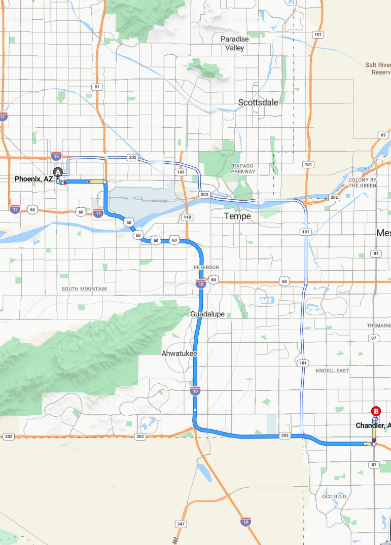
The drive from Phoenix to Chandler typically takes around 30 minutes, covering approximately 24.2 miles. This route primarily follows the I-10 E and AZ-202 E Loop highways, ensuring a smooth and efficient journey. Traffic conditions and time of day may influence the overall travel time, so planning accordingly is advisable. Traveling between these two cities offers a convenient connection within the Phoenix metropolitan area, making it an accessible commute for residents and visitors alike.
Driving route
Traveling from Phoenix to Chandler offers a scenic drive through several vibrant communities. Starting in Phoenix, you pass through the suburban neighborhood of Ahwatukee, known for its family-friendly atmosphere, before reaching the diverse town of Guadalupe. Continuing through Tempe, home to Arizona State University, travelers can enjoy a lively college town vibe. The route also takes you through Scottsdale, renowned for its upscale shopping and vibrant arts scene, and Paradise Valley, which offers luxurious resorts and scenic desert landscapes. Finally, the journey concludes in Chandler, a flourishing city recognized for its high-tech industry and community events, making this route a diverse showcase of Greater Phoenix's dynamic regions.
Traffic conditions and peak hours
Traveling from Phoenix to Chandler, drivers should be aware of varying traffic conditions throughout the day. Peak hours typically occur on weekdays between 7:00 AM and 9:00 AM in the morning and from 4:00 PM to 6:30 PM in the evening, leading to heavier congestion along major routes through Ahwatukee, Tempe, and Scottsdale. During these times, delays may also extend into nearby areas such as Paradise Valley and Gila River Indian Reservation. To avoid heavy traffic, it is advisable to plan travel outside of peak hours or allow extra time for the journey.
Best Route Options and Alternatives
When traveling from Phoenix to Chandler, the most direct route is via the Loop 101 South, which offers a quick and efficient drive through areas like Tempe and Scottsdale. Alternative routes include taking the US-60 East to Gilbert Road, providing access to Chandler's northern neighborhoods and avoiding potential traffic congestion on the freeway. For a more scenic drive, consider using the Arizona Avenue or Ray Road corridors, which pass through Ahwatukee and Guadalupe. Travelers should also stay updated on real-time traffic conditions, as options may vary depending on construction, peak hours, or local events in the Gila River Indian Reservation and Sun Lakes areas.
Road Closures and Construction Updates
Travelers heading from Phoenix to Chandler should stay informed about current road closures and construction updates to ensure a smooth journey. Ongoing roadwork may impact key routes such as the I-10 and Loop 101, especially in areas like Tempe and Scottsdale. Local authorities recommend checking real-time traffic alerts before departure to navigate potential delays effectively. Staying updated will help travelers avoid congestion and reach their destination efficiently.
Scenic Stops and Points of Interest
As you drive from Phoenix to Chandler, there are numerous scenic stops and points of interest worth exploring along the route. In Ahwatukee, visitors can enjoy picturesque desert views and local parks such as South Mountain Park, offering panoramic vistas of the city. Tempe features the beautiful Mill Avenue District and nearby Tempe Town Lake, perfect spots for outdoor recreation and scenic walks. Continuing through Scottsdale and Paradise Valley, travelers can explore art galleries, resorts, and lush golf courses set against stunning desert backdrops, while the Gila River Indian Reservation provides a unique cultural experience with traditional art and heritage sites.
Travel Safety Tips and Precautions
When traveling from Phoenix to Chandler, it's essential to prioritize safety by staying alert and focused on the road, especially when passing through busy areas like Tempe and Scottsdale. Ensure your vehicle is well-maintained and equipped with necessary emergency supplies in case of unforeseen incidents, particularly when crossing remote regions like the Gila River Indian Reservation and Sun Lakes. Obey traffic laws, adhere to speed limits, and avoid distractions such as mobile devices to prevent accidents. Additionally, plan your route ahead of time, stay updated on weather conditions, and take regular breaks to maintain alertness, ensuring a safe and smooth journey through all en route communities.
Fuel Stations and Rest Stops Along the Route
Traveling from Phoenix to Chandler offers multiple fuel stations and rest stops along the route, ensuring convenient refueling and breaks. In Phoenix and Ahwatukee, numerous gas stations are readily available, providing easy access to fuel and amenities. As you pass through Tempe and Scottsdale, additional service stations and nearby cafes offer opportunities to refresh before continuing your journey. Closer to Chandler, variety of rest stops and fuel stations ensure travelers can comfortably complete their trip without concern.
Weather Impact on Driving Conditions
Weather conditions can significantly influence driving safety along the route from Phoenix to Chandler, passing through prominent areas such as Tempe and Scottsdale. While the region generally experiences warm, dry weather, sudden rainstorms or high temperatures can create hazards like slick roads or overheating. Heavy rains can lead to reduced visibility and localized flooding, especially near the Gila River Indian Reservation, impacting travel plans. Therefore, drivers should stay alert to weather updates and adjust their speed and driving behavior to ensure safety throughout their journey.
Local Traffic Laws and Regulations
When driving from Phoenix to Chandler, it is important to adhere to local traffic laws and regulations to ensure safety and compliance. Speed limits vary across the route, typically ranging from 25 to 45 miles per hour, and must be strictly observed, especially in residential areas like Ahwatukee and Sun Lakes. The use of seat belts is mandatory for all passengers, and texting while driving is prohibited throughout the region. Additionally, drivers should be aware of specific local rules, such as yield requirements at certain intersections and restrictions on cell phone use in school zones, to navigate efficiently and responsibly.
Leave a comment