Current Road Condition and Route Map
| Select | Stop Name | Type |
|---|---|---|
| Rawhide Western Town | Point of Interest | |
| Wild Horse Pass | Point of Interest / Gas | |
| Ak-Chin Circle Center | Point of Interest | |
| Harrah's Ak-Chin Casino | Point of Interest | |
| Copper Sky Recreation Complex | Rest Area / Park | |
| Sonoran Desert National Monument | Scenic Point of Interest | |
| Space Age Lodge | Point of Interest / Restaurant | |
| Gila Bend 9/11 Memorial Park | Point of Interest | |
| Gila Bend Museum | Point of Interest | |
| Love's Travel Stop | Gas Station / Rest Area |

Distance and estimated driving time
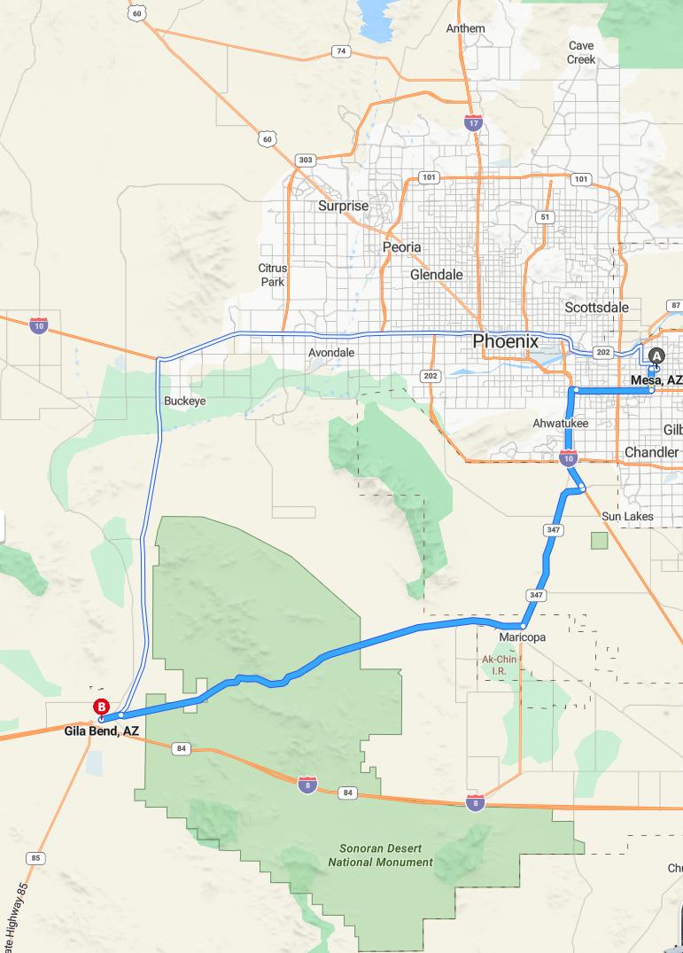
The drive from Mesa to Gila Bend covers approximately 75 miles and is expected to take around 1 hour and 16 minutes. Travelers will primarily use AZ-347 and AZ-238 highways, ensuring a relatively straightforward route. This scenic journey offers a glimpse of Arizona's diverse landscape, making it an enjoyable trip. Planning ahead will help optimize travel time and ensure a smooth adventure between these two locations.
Driving route
Traveling from Mesa to Gila Bend, travelers will pass through several notable communities along the route. Starting in Mesa, located in the northeastern part of the Phoenix metropolitan area, the journey first takes you southward through Ahwatukee, a suburban neighborhood renowned for its scenic views and family-friendly amenities. Continuing southwest, you'll traverse Gilbert and Chandler, both vibrant cities offering a mix of cultural attractions and commercial hubs. Further along, the route passes through Sun Lakes and Maricopa, charming communities known for their active lifestyles and welcoming atmospheres. Finally, approaching Gila Bend, located in western Arizona, travelers will encounter the Ak-Chin Indian Reservation before reaching their destination, offering a glimpse into local Native American culture.
Traffic conditions and best travel time
Driving from Mesa to Gila Bend offers a relatively smooth journey with moderate traffic, particularly during mid-morning and early evening rush hours. Morning travelers are advised to depart before 7:30 a.m. to avoid peak congestion, while late afternoon and evening periods between 4:30 p.m. and 6:30 p.m. tend to see increased traffic, especially near Chandler and Sun Lakes. Midday hours around 11 a.m. to 1 p.m. typically provide the most open road conditions for a faster, more comfortable drive. Planning your trip during these off-peak times can ensure a safer and more efficient travel experience along this route.
Road conditions and construction updates
As of October 2023, driving from Mesa to Gila Bend offers relatively smooth road conditions, with ongoing maintenance projects focused on enhancing safety and traffic flow. Travelers should be aware of occasional construction near Gilbert and Chandler, where lane closures may cause minor delays. The route through Sun Lakes and Maricopa remains well-maintained, though drivers should watch for any temporary speed restrictions. Overall, the highway from Mesa to Gila Bend is reliable, with periodic updates provided by local agencies to ensure a safe journey.
Points of interest along the route
During your drive from Mesa to Gila Bend, you'll encounter several points of interest that highlight the region's unique character. Starting in Mesa, you can explore vibrant arts districts and nearby parks such as the Mesa Arts Center and Usery Mountain Regional Park. As you pass through Gilbert and Chandler, enjoy family-friendly attractions like the SanTan Village shopping center and the Oasis Water Park. Continuing through Sun Lakes and Maricopa, consider visiting local golf courses and scenic lakes, culminating in the Ak-Chin Indian Resort near Gila Bend for a unique cultural experience and gaming entertainment.
Safety tips for long drives
When embarking on a long drive from Mesa to Gila Bend, it's essential to prioritize safety to ensure a smooth journey. Before departure, ensure your vehicle is in good condition by checking tire pressure, fluid levels, and brakes. During the drive, take regular breaks in locations like Ahwatukee, Gilbert, and Chandler to rest and stay alert, especially as you pass through less populated areas like Sun Lakes and Maricopa. Additionally, stay focused on the road by avoiding distractions, adhere to speed limits, and keep emergency supplies handy in case of unforeseen situations along the route.
Vehicle preparation and maintenance tips
Before embarking on a road trip from Mesa to Gila Bend, ensure your vehicle is well-prepared for the journey. Check tire pressure and tread depth to prevent flats and ensure proper handling on long stretches of highway. Additionally, verify fluid levels such as engine oil, coolant, and windshield washer fluid to keep your vehicle running smoothly. Finally, inspect your brakes and lights for safety, and consider packing emergency supplies like water, a spare tire, and a basic toolkit in case of unforeseen issues along the route.
Local weather forecast during travel
During your journey from Mesa to Gila Bend, travelers can expect generally warm and dry weather conditions typical of central Arizona in the fall. Daytime temperatures are likely to range from the mid-80s to low 90s Fahrenheit, with clear skies providing excellent visibility along the route. Humidity levels remain low, and breezy conditions may occur, especially near desert areas such as Ak-Chin I.R. and Gila Bend. It's advisable to stay hydrated and wear sun protection throughout the drive to ensure a safe and comfortable trip.
Fuel stations and convenience stores en route
Travelers driving from Mesa to Gila Bend can find several fuel stations and convenience stores along the route, ensuring a comfortable and efficient trip. In Ahwatukee and Gilbert, there are multiple gas stations offering quick fuel top-ups, along with convenience stores for snacks and beverages. As you pass Chandler and Sun Lakes, additional fuel options and stores provide conveniences for travelers. Near Maricopa and Ak-Chin Indian Reservation, various fueling stations and shops are available, making it easy to refuel and grab essentials before reaching Gila Bend.
Alternative routes and detour options
When traveling from Mesa to Gila Bend, there are several alternative routes and detour options to consider. Travelers can choose to take the more scenic Route 87 through towns like Chandler and Sun Lakes, enjoying a leisurely drive before reaching Maricopa and Ak-Chin I.R. However, during peak hours or in case of road closures, an alternative is to take the faster I-10 West directly from Gilbert or Chandler, bypassing some of the smaller towns. Additionally, detours through local roads can be planned via Florence or Buckeye, providing options to avoid construction or heavy traffic along the main highway. Planning ahead with real-time traffic updates can help select the most efficient route for your journey.

Leave a comment